1970s Maps of Odell, Oregon
Explore 2 historic maps of Odell from the 1970s. These maps offer a rare glimpse into what life looked like during the 1970s — showing old roads, neighborhoods, homes, and landmarks that have changed or disappeared over time.
Whether you're researching your family's past, planning a metal detecting trip, or studying how Odell's landscape evolved across the 1970s, these high-resolution maps are a powerful tool for exploring the history of this region.
- Focus on a specific era: All maps on this page are from the 1970s, giving you a focused view of this time period.
- See what’s changed: Compare century-old streets, trails, and buildings to today's modern landscape using overlays and satellite layers.
- Research with precision: Use these maps for genealogy, historical research, land use analysis, or educational projects.
- View, download, or print: Maps are fully viewable online in high resolution, and can be downloaded or printed for your own records.
Start exploring Odell's history through authentic maps from the 1970s. This is your window into the past.
Odell, OR maps
(2)- 1975 Map of Hood River NE, 1979 Print
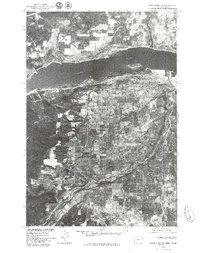 1975 Hood River NE1979 Print · USGSThe mid-seventies landscape of the Columbia River Gorge is captured in this detailed aerial survey. Researchers can trace the development of Hood River and Odell along with the winding course of the Hood River and the industrial riverfront.2 unique versions available
 - 1979 Map of Hood River, 1980 Print
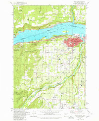 1979 Hood River1980 Print · USGSThe Columbia River corridor thrives in the late seventies as a hub of transport and agriculture. Trace local family roots and early infrastructure at Idelwilde Cem, Frankton Sch, and the Powerdale Dam.
End of results
Showing maps 1-2 of 2
Top cities near Odell
Frequently asked questions
- What are the different types of historical maps available for Odell?
- What is the oldest map of Odell?
- Where can I purchase historical maps of Odell for my home or office?
- Where can I download high-res historical maps of Odell?
- Are there historical topographic maps available for Odell?
- Is there historical aerial imagery available for Odell?
- Where are historical maps of Odell sourced from?