1980s Maps of Culver, Oregon
Explore 2 historic maps of Culver from the 1980s. These maps offer a rare glimpse into what life looked like during the 1980s — showing old roads, neighborhoods, homes, and landmarks that have changed or disappeared over time.
Whether you're researching your family's past, planning a metal detecting trip, or studying how Culver's landscape evolved across the 1980s, these high-resolution maps are a powerful tool for exploring the history of this region.
- Focus on a specific era: All maps on this page are from the 1980s, giving you a focused view of this time period.
- See what’s changed: Compare century-old streets, trails, and buildings to today's modern landscape using overlays and satellite layers.
- Research with precision: Use these maps for genealogy, historical research, land use analysis, or educational projects.
- View, download, or print: Maps are fully viewable online in high resolution, and can be downloaded or printed for your own records.
Start exploring Culver's history through authentic maps from the 1980s. This is your window into the past.
Culver, OR maps
(2)- 1983 Map of Madras
 1983 Madras1983 Print · USGSJefferson County and the Warm Springs Indian Reservation are shown in detail during the early 1980s, from the Cascade peaks to the high desert. Researchers can trace the legacy of tribal lands at Simnasho, find the Abbot Cemetery, or follow the rail lines through Madras Sta.
 - 1985 Map of Culver, 1986 Print
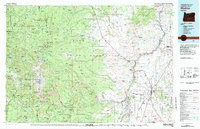
 1985 Culver1986 Print · USGSJefferson County's high desert plateau comes into sharp focus during the mid-eighties, showing the agricultural grids and rail lines connecting Culver and Metolius. Genealogists and historians can trace local landmarks like German Cem, the Burlington Northern tracks, and the Haystack Dam.2 unique versions available
End of results
Showing maps 1-2 of 2
Top cities near Culver
Frequently asked questions
- What are the different types of historical maps available for Culver?
- What is the oldest map of Culver?
- Where can I purchase historical maps of Culver for my home or office?
- Where can I download high-res historical maps of Culver?
- Are there historical topographic maps available for Culver?
- Is there historical aerial imagery available for Culver?
- Where are historical maps of Culver sourced from?