1983 Map of Madras
USGS Topo · Published 1983About this map
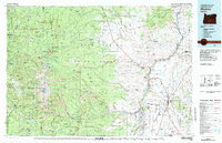
Warm Springs Indian Reservation dominates the central landscape of this 1983 topographic study, illustrating the complex intersection of indigenous land, national forests, and growing agricultural communities. The terrain transitions from the high peaks of the Mt Hood National Forest and Mt Jefferson Wilderness down to the dramatic canyons carved by the Deschutes River and Metolius River. The presence of Kahneeta Hot Springs and the The Cove Palisades State Park highlights the region's development as a recreational hub during the early 1980s.
Find a feature on this map
89 named features on this map. Tap any name to fly to it.
Don’t see what you’re looking for? This feature index may not catch every label — zoom into the map to look around manually.
Map Details
Editions of this 1983 Madras Map
This is the sole edition of this map. No revisions or reprints were ever made.
Historical Maps of Madras Through Time
3 maps found