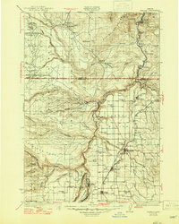
1928 Map of Madras
USGS Topo · Published 1956About this map
Madras and the surrounding high desert plateaus of Jefferson County are captured here during a period of agricultural expansion and infrastructure development. The landscape is defined by the deep incisions of the Deschutes River, the Metolius River, and the Crooked River, which converge near The Peninsula and The Island. To the northwest, the Warm Springs Indian Agency and settlements like Simnasho mark the tribal lands, while the eastern plains show the established grid of the The Dalles California Highway and the Union Pacific railroad. Numerous rural schools, such as New Era Sch and Frog Spring Sch, indicate a once-dispersed population of homesteading families. The presence of Hebe Mill and Foster Mill near Hehe Butte suggests the importance of early timber or milling operations in the western timbered foothills before the era of modern irrigation fully transformed the region.
Find a feature on this map
77 named features on this map. Tap any name to fly to it.
Don’t see what you’re looking for? This feature index may not catch every label — zoom into the map to look around manually.
Map Details
Editions of this 1928 Madras Map
This is the sole edition of this map. No revisions or reprints were ever made.
Historical Maps of Madras Through Time
3 maps found