
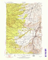
1930 Map of Dufur
USGS Topo · Published 1945About this map
The Great Southern Railroad (Abandoned) traces a winding path through the wheat-growing country of northern Oregon, terminating near Friend. This 1930s survey reveals a landscape deeply connected to the pioneer era, most notably through the alignment of the Barlow Road as it moves westward toward the Cascades. The map documents an extensive network of small rural schoolhouses that served isolated ranching and farming families, such as Pleasant Ridge Sch, Rail Hollow Sch, and Batty Sch.
Find a feature on this map
71 named features on this map. Tap any name to fly to it.
Don’t see what you’re looking for? This feature index may not catch every label — zoom into the map to look around manually.
Map Details
Editions of this 1930 Dufur Map
2 editions found
Other maps of this area

1924 · Mount Hood
USGS Topo · 1:125,000

1926 · Hood River
USGS Topo · 1:125,000

1927 · Mount Hood
USGS Topo · 1:125,000

1927 · Mt. Jefferson
USGS Topo · 1:125,000

1928 · Madras
USGS Topo · 1:125,000

1929 · Hood River
USGS Topo · 1:125,000

1930 · Mt. Jefferson
USGS Topo · 1:125,000

1931 · Madras
USGS Topo · 1:125,000

1934 · Dufur
USGS Topo · 1:125,000

1934 · The Dalles
USGS Topo · 1:125,000