Old Maps of Wasco County, Oregon
Explore 410 old maps of Wasco County, spanning from 1916 to today. These high-resolution historic maps reveal how streets, neighborhoods, landmarks, and natural features evolved over time — perfect for genealogy, metal detecting, research, and local history exploration.
What you can do with these maps:
- See how Wasco County changed over time: Compare historical maps to modern-day views to trace roads, homesites, rail lines & more.
- View detailed metadata: Each map includes creators, publishers, year, scale, and archive source.
- Overlay maps with satellite & LiDAR: Visualize the past alongside modern tools to explore terrain & human change.
- Trusted historical sources: Maps sourced from the USGS, Library of Congress, and other archives.
- Access maps your way: View online, download high-res files, or order prints for personal or research use.
Start exploring old maps of Wasco County to uncover forgotten places, hidden landmarks, and the deep history beneath your feet.
Wasco County, OR maps
(410)- 1916 Map of Condon
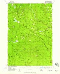
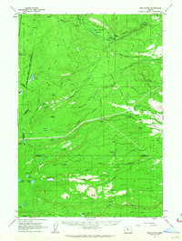
 1916 Condon1916 Print · USGSNorth-central Oregon at the start of the twentieth century was a land of high plateaus and deep canyons centered on the Condon wheat country. Genealogists can trace a vast network of rural schoolhouses like Linville School and Buckhorn School, alongside early rail stops at Mikkalo and Gwendolen.3 unique versions available
 - 1924 Map of Mount Hood, 1955 Print
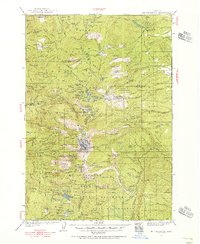
 1924 Mount Hood1955 Print · USGSMount Hood and its surrounding high-country settlements are captured here in the mid-twenties during the rise of mountain recreation. Trace early roads and landmarks like the Mt Hood Loop Highway, Government Camp, and the original Timberline Cabin.2 unique versions available
 - 1926 Map of Mitchell
 1926 Mitchell1926 Print · USGSCentral Oregon ranching and geology are documented here in the mid-1920s, showing a landscape defined by the winding John River. Genealogists can locate family holdings like Old Frizzell Ranch and Laird Ranch alongside remote schoolhouses like Gable School.3 unique versions available
 - 1927 Map of Mount Hood
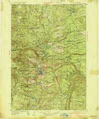
 1927 Mount Hood1927 Print · USGSThe northern Cascades transition from pioneer travel routes to early forest management in the mid-1920s. Researchers can trace the legendary Barlow Road, locate historic mountain retreats like the Cloud Cap Inn, and find early outposts at Government Camp.4 unique versions available
 - 1927 Map of Mt. Jefferson, 1956 Print
 1927 Mt. Jefferson1956 Print · USGSThe Oregon Cascades in the late twenties were defined by high-altitude trails and the early management of the Santiam and Mount Hood forests. Trace the historic Skyline Trail past remote outposts like Lemiti Ranger Sta and the Breitenbush Hot Sprs.2 unique versions available
 - 1928 Map of Madras, 1956 Print
 1928 Madras1956 Print · USGSJefferson County was a landscape of high plateaus and deep river canyons in the late twenties, where new highways met tribal lands. Genealogists can trace family footprints at Hebe Mill, Simnasho, and rural schoolhouses like Mountain View Sch.
 - 1930 Map of Mt. Jefferson
 1930 Mt. Jefferson1930 Print · USGSThe Oregon Cascades were a frontier of early forest management and tribal lands during the late 1920s. Researchers can locate remote administrative outposts like the Lemiti Ranger Sta, trace the thermal waters of Breitenbush Hot Sprs, and explore the high meadows of Independence Prairie.3 unique versions available
 - 1930 Map of Dufur, 1945 Print
 1930 Dufur1945 Print · USGSWasco County at the start of the 1930s shows a transition from pioneer wagon routes to a rail-and-ranch economy. Genealogists can locate dozens of country schools like Ireland Sch and early infrastructure including the Barlow Road and the Great Southern Railroad.2 unique versions available
 - 1931 Map of Madras
 1931 Madras1931 Print · USGSCentral Oregon ranching and rail life come into focus in the late twenties, centering on the Warm Springs Agency. Trace the river-level rail stops at Mecca and Kaskela or locate early rural schoolhouses like New Era Sch and Lyle Gap Sch.2 unique versions available
 - 1934 Map of Dufur
 1934 Dufur1934 Print · USGSWasco County during the mid-1930s reveals a landscape of high plateaus and river canyons shaped by pioneering roads and rail. Genealogists can trace family roots through a dense network of rural schoolhouses like Kelly Sch and Wolf Run Sch, or follow the path of the historic Barlow Road.2 unique versions available
 - 1934 Map of The Dalles
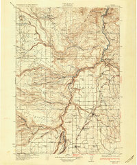
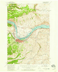
 1934 The Dalles1934 Print · USGSThe Columbia River Gorge in the early thirties reveals a complex network of rapids and river engineering before the completion of major modern dams. Local historians can trace early school districts like Threemile Sch and family landmarks such as Clancy Ranch or Petersburg.4 unique versions available
 - 1953 Map of The Dalles, 1965 Print
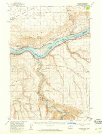
 1953 The Dalles1965 Print · USGSThe Columbia River Gorge at mid-century shows a region being transformed by massive hydroelectric dams and a growing highway network. Researchers can trace the development of The Dalles Dam, locate the Maryhill Museum, and find old rail stops in Rufus, Wishram, and Arlington.3 unique versions available
 - 1955 Map of Bend, 1964 Print
 1955 Bend1964 Print · USGSCentral Oregon was undergoing significant growth in the mid-1960s as irrigation and infrastructure transformed the high desert. Researchers can trace the path of the Oregon Trunk Line, locate old stops like Gateway, and find landmarks like Lava Butte or the Grange.3 unique versions available
 - 1956 Map of The Dalles
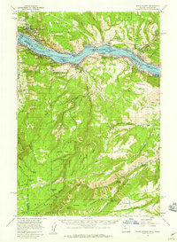
 1956 The Dalles1956 Print · USGSThe Columbia River Gorge and the high Cascades are captured in the mid-1950s, showing a vital corridor of rail and road. Researchers can trace the original path of The Old Oregon Trail or locate historical landmarks like the Maryhill Museum and Mount Hood.
 - 1956 Map of High Rock, 1958 Print
 1956 High Rock1958 Print · USGSThe Clackamas River backcountry in the mid-fifties is defined by new reservoirs and long-standing wilderness trails. You can trace the historic Oregon Skyline Trail as it passes Timothy Meadows Reservoir and the remote Pot Cr Cabin.3 unique versions available
 - 1956 Map of Mt. Wilson, 1958 Print
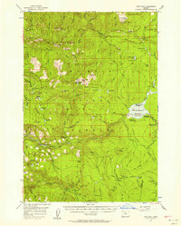
 1956 Mt. Wilson1958 Print · USGSThe high Cascades of Wasco County are captured in the mid-fifties, showing the historic Barlow Road and the timbered reaches of the Mt Hood National Forest. Researchers can trace the old paths to Klingers Camp, the Bear Springs Ranger Station, and high-country landmarks like Wapinitia Pass.3 unique versions available
 - 1957 Map of Bend
 1957 Bend1957 Print · USGSCentral Oregon in the mid-fifties is a landscape of transition between the high Cascades and the arid volcanic plateau. Local historians can trace the rail corridors of the Oregon Trunk and locate early settlements like Ashwood, Odin Falls, and Camp Sherman.
 - 1957 Map of The Dalles
 1957 The Dalles1957 Print · USGSThe Columbia River Gorge and the high plateaus of the mid-1950s come alive on this detailed survey of northern Oregon and southern Washington. Researchers can trace the path of the Oregon Trail and The Old Barlow Road alongside river towns like The Dalles and Wishram.
 - 1957 Map of The Dalles, 1959 Print
 1957 The Dalles1959 Print · USGSThe Dalles and the Columbia River frontier are captured here in the late fifties, just as the new dam transformed the river. Genealogists can locate family schools like Fairfield Sch and Chenoweth School or trace the early footprint of Dallesport.3 unique versions available
 - 1957 Map of Wishram, 1959 Print
 1957 Wishram1959 Print · USGSThe Columbia Gorge in the late fifties was a powerhouse of rail transport and river management. Trace the junction of the S P & S and Union Pacific railroads near Wishram, and find rural landmarks like the Stonehenge Memorial and Douglas Hollow School.2 unique versions available
 - 1957 Map of White Salmon, 1959 Print
 1957 White Salmon1959 Print · USGSThe Columbia River Gorge in the late fifties shows a bustling corridor of rail and river transport. Researchers can locate family landmarks like Ketchum Ranch, old meeting halls such as Mill Creek Grange, and the riverfront communities of Bingen and Mosier.2 unique versions available
 - 1958 Map of Bend
 1958 Bend1958 Print · USGSCentral Oregon in the late fifties was a land of high desert ranching and growing mountain towns. Researchers can trace the rail lines of the Oregon Trunk Railroad, find established settlements like Madras and Sisters, or locate landmarks such as Smith Rock and Lava Butte.
 - 1961 Map of Fort Butte, 1963 Print
 1961 Fort Butte1963 Print · USGSThe high Cascades of Wasco and Jefferson counties are captured here in the early sixties, showing a landscape shaped by timber and range. Researchers can trace the drainage of Shitike Creek or locate local landmarks like Old Mill Camp and the Schoolie Pasture.2 unique versions available
 - 1961 Map of Breitenbush Hot Springs, 1964 Print
 1961 Breitenbush Hot Springs1964 Print · USGSThe Oregon Cascades in the early 1960s are documented here during a period of active Forest Service management and recreational growth. Trace the development of Breitenbush Hot Springs or locate remote landmarks like the Rho Ridge Shelter and the Clackamas Ranger Sta.3 unique versions available
 - 1962 Map of Sherars Bridge
 1962 Sherars Bridge1962 Print · USGSThe Deschutes River canyon serves as a vital transit and recreation corridor during the early sixties. Follow the historic rail lines of the Northern Pacific and trace local landmarks like Sherars Bridge, Warner Cemetery, and Sherar.3 unique versions available
Showing maps 1-25 of 410
Top cities of Wasco County
- The Dalles historical maps
- Chenowith historical maps
- Dufur historical maps
- Maupin historical maps
- Mosier historical maps
- Antelope historical maps
See more
Frequently asked questions
- What are the different types of historical maps available for Wasco County?
- What is the oldest map of Wasco County?
- Where can I purchase historical maps of Wasco County for my home or office?
- Where can I download high-res historical maps of Wasco County?
- Are there historical topographic maps available for Wasco County?
- Is there historical aerial imagery available for Wasco County?
- Where are historical maps of Wasco County sourced from?