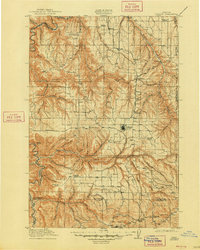
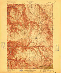
1916 Map of Condon
USGS Topo · Published 1948About this map
The John Day River winds through deep canyons on this plateau map of Gilliam County, marking the western boundary with Sherman County. Surveyed just before the First World War, the landscape is defined by an extensive network of school districts and isolated ranching outposts. The county seat of Condon serves as the central hub, surrounded by smaller rail-line or stage-road settlements like Mikkalo, Clem, and Gwendolen. The deep incisions of Thirtymile Creek and Rock Creek create a rugged geography where travel was dictated by the terrain of Cottonwood Canyon and the Devils Backbone. Numerous rural educational landmarks, such as Huffs School and Linville School, show the distribution of family homesteads across the high desert during this era of early twentieth-century settlement. In the south, the village of Fossil sits near the headwaters of Butte Creek, illustrating the early footprint of Wheeler County.
Find a feature on this map
84 named features on this map. Tap any name to fly to it.
Don’t see what you’re looking for? This feature index may not catch every label — zoom into the map to look around manually.
Map Details
Editions of this 1916 Condon Map
3 editions found
Other maps of this area

1906 · Blalock Island
USGS Topo · 1:125,000

1908 · Blalock Island
USGS Topo · 1:125,000

1916 · Arlington
USGS Topo · 1:125,000

1916 · Condon
USGS Topo · 1:125,000

1926 · Mitchell
USGS Topo · 1:125,000
1953 · Spray
USGS Topo · 1:62,500

1953 · Pendleton
USGS Topo · 1:250,000

1953 · The Dalles
USGS Topo · 1:250,000

1955 · Bend
USGS Topo · 1:250,000

1955 · Canyon City
USGS Topo · 1:250,000