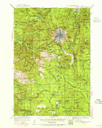
1924 Map of Mount Hood
USGS Topo · Published 1955About this map
Mt Hood stands at the center of this 1924 survey, which documents the early mountaineering and transit infrastructure around Oregon's highest peak. Before the modern development of the ski resorts, the map shows the primary access points via the Mt Hood Loop Highway and the historic Barlow Road. Early mountaineering landmarks are prominently featured, including the Timberline Cabin, Camp Blossom, and the Mt Hood Lodge. The settlement pattern follows the western approach along the Zigzag River, where clusters like Welches, Rhododendron, and Wemme were established. To the south, the landscape transitions into the heavily forested reaches of the Mount Hood National Forest and the northern border of the Warm Springs Indian Reservation, characterized by high-elevation lakes such as Clear Lake and Clackamas Lake. The map captures a transition era where traditional trails and cabins still defined the backcountry experience for early 20th-century travelers.
Find a feature on this map
152 named features on this map. Tap any name to fly to it.
Don’t see what you’re looking for? This feature index may not catch every label — zoom into the map to look around manually.
Map Details
Editions of this 1924 Mount Hood Map
2 editions found
Other maps of this area

1916 · Estacada
USGS Topo · 1:125,000

1924 · Mount Hood
USGS Topo · 1:125,000

1926 · Hood River
USGS Topo · 1:125,000

1927 · Mount Hood
USGS Topo · 1:125,000

1927 · Mt. Jefferson
USGS Topo · 1:125,000

1928 · Madras
USGS Topo · 1:125,000

1929 · Mill City
USGS Topo · 1:125,000

1929 · Hood River
USGS Topo · 1:125,000

1930 · Mt. Jefferson
USGS Topo · 1:125,000

1930 · Dufur
USGS Topo · 1:125,000