1926 Map of Mitchell
USGS Topo · Published 1926About this map
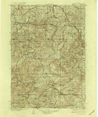
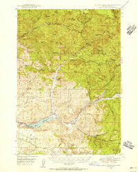
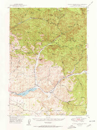
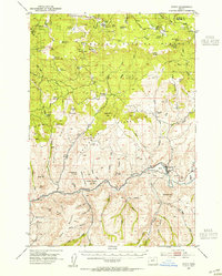
The John Day River snakes through the central portion of this 1920s topography, illustrating the high-desert homesteading era in Wheeler County. Central to the map is the town of Mitchell, surrounded by a landscape defined by prominent uplifted features like Sutton Mountain and Keyes Mountain. The presence of numerous family-named landmarks, such as Old Frizzell Ranch, Taylor Ranch, and Wagner Ranch, highlights the scattered nature of ranching operations that relied on the region's scattered springs and creeks. Education in this sparsely populated territory is marked by a network of small, rural institutions including Twickenham School, Butte Creek School, and Waldron School. In the south, the boundary of the Ochoco National Forest indicates the shift from open rangeland to managed timber, while the Painted Hills appear as a distinct geological formation long before the area's modern designation as a national monument.
Find a feature on this map
104 named features on this map. Tap any name to fly to it.
Don’t see what you’re looking for? This feature index may not catch every label — zoom into the map to look around manually.
Map Details
Editions of this 1926 Mitchell Map
3 editions found
Other maps of this area

1916 · Condon
USGS Topo · 1:125,000

1926 · Mitchell
USGS Topo · 1:125,000
1932 · Dayville
USGS Topo · 1:125,000
1936 · Dayville
USGS Topo · 1:125,000
1948 · Ochoco Reservoir
USGS Topo · 1:62,500
1950 · Ochoco Reservoir
USGS Topo · 1:62,500
1951 · Lookout Mtn
USGS Topo · 1:62,500
1953 · Richmond
USGS Topo · 1:62,500
1953 · Spray
USGS Topo · 1:62,500

1953 · Pendleton
USGS Topo · 1:250,000