
Loading...
Loading map...1934 Map of Dufur
USGS Topo · Published 1934About this map
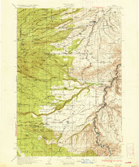
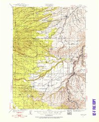
Juniper Flat dominates the central landscape of this Wasco County region, where the Deschutes River carves a deep path along the eastern edge. The map captures a transition between the established grain-growing settlements like Dufur and the southern reaches bordering the Warm Springs Indian Reservation. The Great Southern Railroad provides a vital transportation link for the northern half, terminating near Friend, while the historic Barlow Road traces a pioneer route through the southwest.
Find a feature on this map
102 named features on this map. Tap any name to fly to it.
Don’t see what you’re looking for? This feature index may not catch every label — zoom into the map to look around manually.
Map Details
Date Portrayed1934
Date Published1934
PublisherU.S. Geological Survey
Map TypeTopographic
Scale1:125,000
Physical Dimensions16.5 x 19.7 inches
Editions of this 1934 Dufur Map
2 editions found
Historical Maps of Dufur Through Time
Featured Locations
Source Details
SourceU.S. Geological Survey
CopyrightPublic Domain