
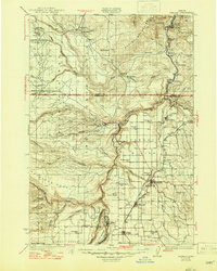
1931 Map of Madras
USGS Topo · Published 1931About this map
The Warm Springs Agency sits at the heart of this central Oregon landscape, where the Warm Springs River and Shitike Creek carve deep canyons through the high plateau. The map details a period of transition as the Oregon Trunk and Union Pacific railroads follow the path of the Deschutes River, connecting remote outposts like Mecca and Kaskela to the growing commercial centers of Madras and Metolius. These river corridors contrast sharply with the broad, dry expanses of Agency Plains and Schoolie Flat, where early schools such as New Era Sch and Mountain View Sch served dispersed ranching families.
Find a feature on this map
68 named features on this map. Tap any name to fly to it.
Don’t see what you’re looking for? This feature index may not catch every label — zoom into the map to look around manually.
Map Details
Editions of this 1931 Madras Map
2 editions found
Other maps of this area

1924 · Mount Hood
USGS Topo · 1:125,000

1926 · Bend
USGS Topo · 1:125,000

1927 · Mount Hood
USGS Topo · 1:125,000

1927 · Mt. Jefferson
USGS Topo · 1:125,000

1928 · Madras
USGS Topo · 1:125,000

1929 · Bend
USGS Topo · 1:125,000

1929 · Three Sisters
USGS Topo · 1:125,000

1930 · Mt. Jefferson
USGS Topo · 1:125,000

1930 · Dufur
USGS Topo · 1:125,000

1932 · Three Sisters
USGS Topo · 1:125,000