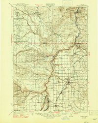
1931 Map of Madras
USGS Topo · Published 1947About this map
The Warm Springs Indian Reservation dominates the western half of this landscape, its boundary defined by the deep canyons of the Deschutes River and the Metolius River. Central to the reservation is the Warm Springs Agency and the settlement of Simnasho, while the high plateau of Schoolie Flat and the Mutton Mountains characterize the upland terrain. To the east, the Agency Plains support a cluster of agricultural settlements including Madras, Metolius, and Culver, connected by the Oregon-California Highway and the Oregon Trunk Railway.
Find a feature on this map
73 named features on this map. Tap any name to fly to it.
Don’t see what you’re looking for? This feature index may not catch every label — zoom into the map to look around manually.
Map Details
Editions of this 1931 Madras Map
2 editions found
Other maps of this area

1924 · Mount Hood
USGS Topo · 1:125,000

1926 · Bend
USGS Topo · 1:125,000

1927 · Mount Hood
USGS Topo · 1:125,000

1927 · Mt. Jefferson
USGS Topo · 1:125,000

1928 · Madras
USGS Topo · 1:125,000

1929 · Bend
USGS Topo · 1:125,000

1929 · Three Sisters
USGS Topo · 1:125,000

1930 · Mt. Jefferson
USGS Topo · 1:125,000

1930 · Dufur
USGS Topo · 1:125,000

1931 · Madras
USGS Topo · 1:125,000