
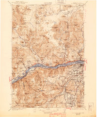
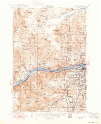
1929 Map of Hood River
USGS Topo · Published 1929About this map
The Columbia River serves as the central artery of this 1920s landscape, dividing the rugged terrain of the Columbia National Forest to the north from the Mount Hood National Forest to the south. Along the river's banks, the engineering of the era is evident in the Bridge of the Gods and the parallel tracks of the Spokane Portland and Seattle Railway and the Union Pacific. The map documents a period when the river was the primary corridor for both commerce and travel, connecting settlements like Stevenson, Cascade Locks, and Bonneville.
Find a feature on this map
130 named features on this map. Tap any name to fly to it.
Don’t see what you’re looking for? This feature index may not catch every label — zoom into the map to look around manually.
Map Details
Editions of this 1929 Hood River Map
3 editions found
Other maps of this area

1904 · Mount Adams
USGS Topo · 1:125,000

1907 · Mount Adams
USGS Topo · 1:125,000

1916 · Estacada
USGS Topo · 1:125,000

1919 · Mount St Helens
USGS Topo · 1:125,000

1924 · Mount Hood
USGS Topo · 1:125,000

1926 · Steamboat Mtn
USGS Topo · 1:125,000

1926 · Hood River
USGS Topo · 1:125,000

1927 · Mount Hood
USGS Topo · 1:125,000

1930 · Dufur
USGS Topo · 1:125,000
1931 · Steamboat Mtn
USGS Topo · 1:125,000