1980s Maps of Opal City, Oregon
Explore 2 historic maps of Opal City from the 1980s. These maps offer a rare glimpse into what life looked like during the 1980s — showing old roads, neighborhoods, homes, and landmarks that have changed or disappeared over time.
Whether you're researching your family's past, planning a metal detecting trip, or studying how Opal City's landscape evolved across the 1980s, these high-resolution maps are a powerful tool for exploring the history of this region.
- Focus on a specific era: All maps on this page are from the 1980s, giving you a focused view of this time period.
- See what’s changed: Compare century-old streets, trails, and buildings to today's modern landscape using overlays and satellite layers.
- Research with precision: Use these maps for genealogy, historical research, land use analysis, or educational projects.
- View, download, or print: Maps are fully viewable online in high resolution, and can be downloaded or printed for your own records.
Start exploring Opal City's history through authentic maps from the 1980s. This is your window into the past.
Opal City, OR maps
(2)- 1980 Map of Bend, 1993 Print
 1980 Bend1993 Print · USGSCentral Oregon was evolving rapidly in the early eighties as outdoor recreation and transit hubs like Bend and Redmond expanded. Trace the historical footprints of Sisters, the Metolius River basin, and the Oregon Trunk Railway through the high desert.2 unique versions available
 - 1985 Map of Opal City, 1986 Print
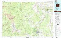
 1985 Opal City1986 Print · USGSJefferson and Deschutes counties are captured here in the mid-1980s as agricultural irrigation and recreation reshaped the high desert. Researchers can trace the sprawling Crooked River Ranch, the tracks of the Union Pacific Northern, and the waters of Haystack Reservoir.
End of results
Showing maps 1-2 of 2
Top cities near Opal City
Frequently asked questions
- What are the different types of historical maps available for Opal City?
- What is the oldest map of Opal City?
- Where can I purchase historical maps of Opal City for my home or office?
- Where can I download high-res historical maps of Opal City?
- Are there historical topographic maps available for Opal City?
- Is there historical aerial imagery available for Opal City?
- Where are historical maps of Opal City sourced from?