1900s (20th Century) Maps of Galice, Oregon
Explore 8 historic maps of Galice from the 1900s (20th Century). These maps offer a rare glimpse into what life looked like during the 1900s — showing old roads, neighborhoods, homes, and landmarks that have changed or disappeared over time.
Whether you're researching your family's past, planning a metal detecting trip, or studying how Galice's landscape evolved across the 1900s, these high-resolution maps are a powerful tool for exploring the history of this region.
- Focus on a specific era: All maps on this page are from the 1900s, giving you a focused view of this time period.
- See what’s changed: Compare century-old streets, trails, and buildings to today's modern landscape using overlays and satellite layers.
- Research with precision: Use these maps for genealogy, historical research, land use analysis, or educational projects.
- View, download, or print: Maps are fully viewable online in high resolution, and can be downloaded or printed for your own records.
Start exploring Galice's history through authentic maps from the 1900s. This is your window into the past.
Galice, OR maps
(8)- 1946 Map of Galice, 1955 Print
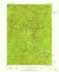 1946 Galice1955 Print · USGSSouthern Oregon's Rogue River corridor is documented here in the mid-forties, highlighting a period when gold mining and forest service outposts defined the region. Researchers can trace the heritage of local claims like the Almeda Mine and settlements such as Galice and Rand.4 unique versions available
 - 1948 Map of Galice
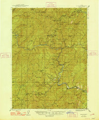 1948 Galice1948 Print · USGSThe Rogue River canyon in the late 1940s reveals a landscape defined by remote forest camps and a storied mining history. Genealogists and historians can trace the locations of the Benton Mine, the riverside settlement of Galice, and Rainie Falls.2 unique versions available
 - 1955 Map of Medford, 1964 Print
 1955 Medford1964 Print · USGSSouthern Oregon's valley towns and high peaks are captured here in the mid-1950s, showing the region before the completion of the modern interstate system. Genealogists and historians can trace the development of timber and mining outposts from Wolf Creek to Butte Falls and the early roads to Crater Lake.3 unique versions available
 - 1957 Map of Medford
 1957 Medford1957 Print · USGSSouthern Oregon during the mid-fifties is captured here as a region of growing valley cities and vast timberlands. Genealogists and historians can trace the rail-and-road corridors connecting Medford, Jacksonville, and Grants Pass to more remote locales like Wolf Creek or Butte Falls.
 - 1958 Map of Medford
 1958 Medford1958 Print · USGSSouthern Oregon's Rogue River valley thrived in the 1950s as a crossroads of rail and road. Researchers can trace the legacy of timber and tourism through Southern Pacific RR lines and landmarks like Crater Lake and Oregon Caves National Monument.
 - 1989 Map of Galice
 1989 Galice1989 Print · USGSThe Rogue River canyon in Josephine County is captured here in the late eighties, showing a balance between its mining heritage and its protected status. Genealogists and historians can trace lode mining sites like Golden Wedge Mine and river features from Hellgate Canyon to the settlement at Galice.
 - 1989 Map of Canyonville
 1989 Canyonville1989 Print · USGSSouthern Oregon's timber and rail corridors come into focus during the late eighties as communities like Canyonville and Riddle anchor the local economy. Researchers can trace the path of the Southern Pacific Railroad and locate early settlements such as Placer, Leland, and Sunny Valley.2 unique versions available
 - 1998 Map of Galice, 2001 Print
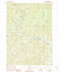
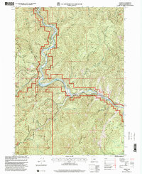 1998 Galice2001 Print · USGSThe Rogue River corridor in the late nineties shows a landscape where historic mining claims meet modern recreation. Local history researchers can trace the locations of the Almeda Mine, Galice settlement, and landmarks like Hellgate Canyon.
End of results
Showing maps 1-8 of 8
Top cities near Galice
Frequently asked questions
- What are the different types of historical maps available for Galice?
- What is the oldest map of Galice?
- Where can I purchase historical maps of Galice for my home or office?
- Where can I download high-res historical maps of Galice?
- Are there historical topographic maps available for Galice?
- Is there historical aerial imagery available for Galice?
- Where are historical maps of Galice sourced from?