1900s (20th Century) Maps of Merlin, Oregon
Explore 8 historic maps of Merlin from the 1900s (20th Century). These maps offer a rare glimpse into what life looked like during the 1900s — showing old roads, neighborhoods, homes, and landmarks that have changed or disappeared over time.
Whether you're researching your family's past, planning a metal detecting trip, or studying how Merlin's landscape evolved across the 1900s, these high-resolution maps are a powerful tool for exploring the history of this region.
- Focus on a specific era: All maps on this page are from the 1900s, giving you a focused view of this time period.
- See what’s changed: Compare century-old streets, trails, and buildings to today's modern landscape using overlays and satellite layers.
- Research with precision: Use these maps for genealogy, historical research, land use analysis, or educational projects.
- View, download, or print: Maps are fully viewable online in high resolution, and can be downloaded or printed for your own records.
Start exploring Merlin's history through authentic maps from the 1900s. This is your window into the past.
Merlin, OR maps
(8)- 1904 Map of Riddle
 1904 Riddle1904 Print · USGSSouthern Oregon's mining and railroad corridor is captured here at the start of the twentieth century. Genealogists can trace family footprints through early settlements like Riddles and Galesville or locate specific claims like the Placer Star Mine.5 unique versions available
 - 1954 Map of Glendale, 1956 Print
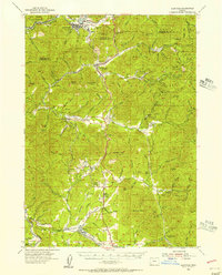 1954 Glendale1956 Print · USGSThe timber and mining country of Douglas and Josephine Counties is captured here in the mid-fifties, centered on the Southern Pacific line. You can trace the lineage of local claims at the Greenback Mine and Steam Beer Placer or find the sites of the Merlin Sanitarium and Aman Ranch.3 unique versions available
 - 1955 Map of Medford, 1964 Print
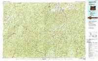
 1955 Medford1964 Print · USGSSouthern Oregon's valley towns and high peaks are captured here in the mid-1950s, showing the region before the completion of the modern interstate system. Genealogists and historians can trace the development of timber and mining outposts from Wolf Creek to Butte Falls and the early roads to Crater Lake.3 unique versions available
 - 1957 Map of Medford
 1957 Medford1957 Print · USGSSouthern Oregon during the mid-fifties is captured here as a region of growing valley cities and vast timberlands. Genealogists and historians can trace the rail-and-road corridors connecting Medford, Jacksonville, and Grants Pass to more remote locales like Wolf Creek or Butte Falls.
 - 1958 Map of Medford
 1958 Medford1958 Print · USGSSouthern Oregon's Rogue River valley thrived in the 1950s as a crossroads of rail and road. Researchers can trace the legacy of timber and tourism through Southern Pacific RR lines and landmarks like Crater Lake and Oregon Caves National Monument.
 - 1986 Map of Merlin
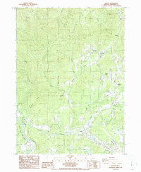 1986 Merlin1986 Print · USGSJosephine County in the mid-1980s shows a landscape of mountain passes and river valleys during a period of rural development. Researchers can trace the proximity of the Merlin Sanitarium to Merlin or locate industrial sites like the Copper Queen Mine and JOSEPHINE COUNTY AIRPORT.
 - 1989 Map of Canyonville
 1989 Canyonville1989 Print · USGSSouthern Oregon's timber and rail corridors come into focus during the late eighties as communities like Canyonville and Riddle anchor the local economy. Researchers can trace the path of the Southern Pacific Railroad and locate early settlements such as Placer, Leland, and Sunny Valley.2 unique versions available
 - 1998 Map of Merlin, 2001 Print
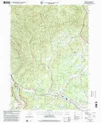 1998 Merlin2001 Print · USGSMerlin and the surrounding Josephine County valleys are shown in detail during the late 1990s as the area balanced rural life with growing aviation and utility infrastructure. Researchers can locate the Merlin Sanitarium, trace the Schoolhouse Trail, and identify local sites like Hugo and the Copper Queen Mine.
End of results
Showing maps 1-8 of 8
Top cities near Merlin
Frequently asked questions
- What are the different types of historical maps available for Merlin?
- What is the oldest map of Merlin?
- Where can I purchase historical maps of Merlin for my home or office?
- Where can I download high-res historical maps of Merlin?
- Are there historical topographic maps available for Merlin?
- Is there historical aerial imagery available for Merlin?
- Where are historical maps of Merlin sourced from?