1960s Maps of Odell Lake, Oregon
Explore 2 historic maps of Odell Lake from the 1960s. These maps offer a rare glimpse into what life looked like during the 1960s — showing old roads, neighborhoods, homes, and landmarks that have changed or disappeared over time.
Whether you're researching your family's past, planning a metal detecting trip, or studying how Odell Lake's landscape evolved across the 1960s, these high-resolution maps are a powerful tool for exploring the history of this region.
- Focus on a specific era: All maps on this page are from the 1960s, giving you a focused view of this time period.
- See what’s changed: Compare century-old streets, trails, and buildings to today's modern landscape using overlays and satellite layers.
- Research with precision: Use these maps for genealogy, historical research, land use analysis, or educational projects.
- View, download, or print: Maps are fully viewable online in high resolution, and can be downloaded or printed for your own records.
Start exploring Odell Lake's history through authentic maps from the 1960s. This is your window into the past.
Odell Lake, OR maps
(2)- 1963 Map of Odell Lake, 1965 Print
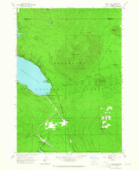 1963 Odell Lake1965 Print · USGSHigh in the Cascades during the early sixties, this area shows the intersection of the Southern Pacific rail line and mountain recreation. Trace the route of the Oregon Skyline Trail past Maiden Peak or locate the Davis Lake Guard Station.2 unique versions available
 - 1967 Map of Odell Lake, 1981 Print
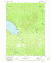 1967 Odell Lake1981 Print · USGSThe high cascades of the Klamath and Deschutes border are captured here in the late sixties, showcasing a landscape of alpine lakes and early recreational development. Researchers can find the Odell Lake Resort, the Crescent Lake Landing Strip, and the historic McCord Cabin tucked near the Southern Pacific tracks.
End of results
Showing maps 1-2 of 2
Frequently asked questions
- What are the different types of historical maps available for Odell Lake?
- What is the oldest map of Odell Lake?
- Where can I purchase historical maps of Odell Lake for my home or office?
- Where can I download high-res historical maps of Odell Lake?
- Are there historical topographic maps available for Odell Lake?
- Is there historical aerial imagery available for Odell Lake?
- Where are historical maps of Odell Lake sourced from?