1900s (20th Century) Maps of Dunes City, Oregon
Explore 10 historic maps of Dunes City from the 1900s (20th Century). These maps offer a rare glimpse into what life looked like during the 1900s — showing old roads, neighborhoods, homes, and landmarks that have changed or disappeared over time.
Whether you're researching your family's past, planning a metal detecting trip, or studying how Dunes City's landscape evolved across the 1900s, these high-resolution maps are a powerful tool for exploring the history of this region.
- Focus on a specific era: All maps on this page are from the 1900s, giving you a focused view of this time period.
- See what’s changed: Compare century-old streets, trails, and buildings to today's modern landscape using overlays and satellite layers.
- Research with precision: Use these maps for genealogy, historical research, land use analysis, or educational projects.
- View, download, or print: Maps are fully viewable online in high resolution, and can be downloaded or printed for your own records.
Start exploring Dunes City's history through authentic maps from the 1900s. This is your window into the past.
Dunes City, OR maps
(10)- 1920 Map of Siltcoos Lake
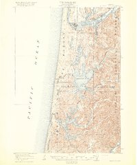 1920 Siltcoos Lake1920 Print · USGSThe Oregon coast at the end of the Great War reveals a landscape of river inlets and timber-driven rail lines. You can trace the Southern Pacific tracks past rural schoolhouses like Idlewild School and old stops at Cushman P.O. or Acme.3 unique versions available
 - 1941 Map of Siltcoos Lake, 1958 Print
 1941 Siltcoos Lake1958 Print · USGSThe Oregon coast at the onset of World War II was a landscape of timber, dunes, and vital freshwater lakes. Researchers can trace the early path of the Oregon Coast Highway past Idlewilde Sch and through settlements like Westlake and Cushman.
 - 1942 Map of Siltcoos Lake
 1942 Siltcoos Lake1942 Print · USGSCoastal Lane County at the start of the 1940s reveals a landscape of massive freshwater lakes and timber-rich national forest. Genealogists and historians can trace the rail stops at Cushman and Ada Sta or locate family landmarks near Siltcoos Lake and the Siuslaw River.
 - 1954 Map of Coos Bay
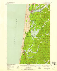
 1954 Coos Bay1954 Print · USGSCoastal Oregon at mid-century shows a landscape of timber and tides, from the river ports to the edge of the Pacific. Researchers can trace family roots through coastal schools like Beachview School or follow the Southern Pacific RR through Reedsport and Coos Bay.
 - 1956 Map of Siltcoos Lake, 1958 Print
 1956 Siltcoos Lake1958 Print · USGSThe Oregon coast in the mid-fifties reveals a landscape of massive dunes and rail-dependent timber towns. Researchers can trace the Southern Pacific line past Siltcoos and Westlake, or locate rural landmarks like Drew Cem and Ada Sta.3 unique versions available
 - 1958 Map of Coos Bay, 1974 Print
 1958 Coos Bay1974 Print · USGSThe Southern Oregon coastline at mid-century reveals a bustling maritime and timber economy centered on Coos Bay and North Bend. Researchers can trace the legacy of coastal settlements from Bandon to Brookings, including rail lines of the Southern Pacific RR and the rugged reaches of the Siuslaw National Forest.
 - 1962 Map of Coos Bay
 1962 Coos Bay1962 Print · USGSThe Oregon coast at the end of the fifties reveals a landscape of timber ports and fishing villages connected by U.S. Highway 101. Researchers can trace the rail infrastructure of the Southern Pacific RR and locate early settlements from Florence down to Brookings.2 unique versions available
 - 1980 Map of Reedsport, 1987 Print
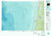 1980 Reedsport1987 Print · USGSThe Oregon coast at the dawn of the 1980s reveals a landscape defined by timber, tourism, and the shifting sands of the Oregon Dunes. Local historians can trace the rail-and-river economy through Reedsport, the historic timber town of Gardiner, and the lakeside community of Lakeside.
 - 1984 Map of Florence
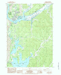 1984 Florence1984 Print · USGSThe Oregon coast at the mid-eighties reveals a landscape defined by the winding Siuslaw River and its industrial rail connections. Trace the heritage of river towns like Cushman and Acme, or locate family landmarks near Drew Cem and Siltcoos.2 unique versions available
 - 1984 Map of Fivemile Creek, 1987 Print
 1984 Fivemile Creek1987 Print · USGSThe Oregon coast at the Douglas and Lane County line is captured here in the early eighties, where the Southern Pacific railroad meets the forest. Genealogists and historians can trace the locations of Ada Station, Fir Grove Cem, and the former settlement at Booth (Site).
End of results
Showing maps 1-10 of 10
Top cities near Dunes City
Top neighborhoods of Dunes City
Frequently asked questions
- What are the different types of historical maps available for Dunes City?
- What is the oldest map of Dunes City?
- Where can I purchase historical maps of Dunes City for my home or office?
- Where can I download high-res historical maps of Dunes City?
- Are there historical topographic maps available for Dunes City?
- Is there historical aerial imagery available for Dunes City?
- Where are historical maps of Dunes City sourced from?