1980s Maps of Florence, Oregon
Explore 5 historic maps of Florence from the 1980s. These maps offer a rare glimpse into what life looked like during the 1980s — showing old roads, neighborhoods, homes, and landmarks that have changed or disappeared over time.
Whether you're researching your family's past, planning a metal detecting trip, or studying how Florence's landscape evolved across the 1980s, these high-resolution maps are a powerful tool for exploring the history of this region.
- Focus on a specific era: All maps on this page are from the 1980s, giving you a focused view of this time period.
- See what’s changed: Compare century-old streets, trails, and buildings to today's modern landscape using overlays and satellite layers.
- Research with precision: Use these maps for genealogy, historical research, land use analysis, or educational projects.
- View, download, or print: Maps are fully viewable online in high resolution, and can be downloaded or printed for your own records.
Start exploring Florence's history through authentic maps from the 1980s. This is your window into the past.
Florence, OR maps
(5)- 1980 Map of Waldport
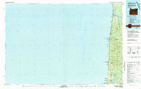 1980 Waldport1980 Print · USGSCoastal Oregon at the start of the 1980s reveals a landscape of rugged headlands and timbered ridges between Waldport and the Siuslaw River. Researchers can trace old beach communities and landmarks like the US Coast Guard Res Lighthouse at Heceta Head and Cape Perpetua.2 unique versions available
 - 1980 Map of Reedsport, 1987 Print
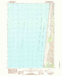
 1980 Reedsport1987 Print · USGSThe Oregon coast at the dawn of the 1980s reveals a landscape defined by timber, tourism, and the shifting sands of the Oregon Dunes. Local historians can trace the rail-and-river economy through Reedsport, the historic timber town of Gardiner, and the lakeside community of Lakeside.
 - 1984 Map of Goose Pasture
 1984 Goose Pasture1984 Print · USGSThe Lane County coast in the mid-eighties shows a landscape of shifting dunes and protected wildlife habitats. Researchers can trace the drainage of the Siltcoos River past the Concrete Dam or locate the Waxmyrtle Campground.
 - 1984 Map of Mercer Lake
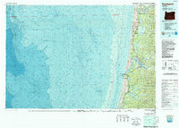
 1984 Mercer Lake1984 Print · USGSThe Central Oregon coast in the mid-eighties shows a landscape of shifting dunes and deep evergreen forests between the Pacific and the Siuslaw River. You can trace the development of Florence and Heceta Beach, locate the Haring Cem, or follow the Southern Pacific rail line.
 - 1984 Map of Florence
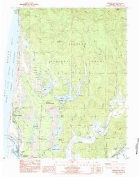
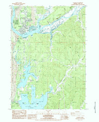 1984 Florence1984 Print · USGSThe Oregon coast at the mid-eighties reveals a landscape defined by the winding Siuslaw River and its industrial rail connections. Trace the heritage of river towns like Cushman and Acme, or locate family landmarks near Drew Cem and Siltcoos.2 unique versions available
End of results
Showing maps 1-5 of 5
Top cities near Florence
Frequently asked questions
- What are the different types of historical maps available for Florence?
- What is the oldest map of Florence?
- Where can I purchase historical maps of Florence for my home or office?
- Where can I download high-res historical maps of Florence?
- Are there historical topographic maps available for Florence?
- Is there historical aerial imagery available for Florence?
- Where are historical maps of Florence sourced from?