1950s Maps of Florence, Oregon
Explore 6 historic maps of Florence from the 1950s. These maps offer a rare glimpse into what life looked like during the 1950s — showing old roads, neighborhoods, homes, and landmarks that have changed or disappeared over time.
Whether you're researching your family's past, planning a metal detecting trip, or studying how Florence's landscape evolved across the 1950s, these high-resolution maps are a powerful tool for exploring the history of this region.
- Focus on a specific era: All maps on this page are from the 1950s, giving you a focused view of this time period.
- See what’s changed: Compare century-old streets, trails, and buildings to today's modern landscape using overlays and satellite layers.
- Research with precision: Use these maps for genealogy, historical research, land use analysis, or educational projects.
- View, download, or print: Maps are fully viewable online in high resolution, and can be downloaded or printed for your own records.
Start exploring Florence's history through authentic maps from the 1950s. This is your window into the past.
Florence, OR maps
(6)- 1953 Map of Salem
 1953 Salem1953 Print · USGSMid-century Oregon comes to life through this detailed survey of the Willamette Valley and the adjacent Pacific coastline. Researchers can trace the rail lines of the Southern Pacific RR, visit rural hubs like Fairview School, or locate coastal landmarks like the Yaquina Head Lighthouse.
 - 1954 Map of Salem
 1954 Salem1954 Print · USGSMid-century Western Oregon is centered on the productive Willamette River valley as its cities and infrastructure expand toward the mountains. Genealogists and historians can trace the rail lines of the Southern Pacific RR and Oregon Electric Ry through towns like Dallas, Independence, and Brownsville.
 - 1954 Map of Coos Bay
 1954 Coos Bay1954 Print · USGSCoastal Oregon at mid-century shows a landscape of timber and tides, from the river ports to the edge of the Pacific. Researchers can trace family roots through coastal schools like Beachview School or follow the Southern Pacific RR through Reedsport and Coos Bay.
 - 1956 Map of Heceta Head, 1958 Print
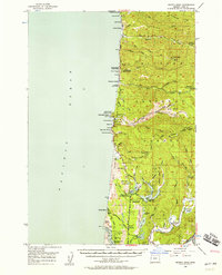 1956 Heceta Head1958 Print · USGSThe Lane County coast during the mid-fifties shows a rugged intersection of timberlands and Pacific shoreline. Researchers can trace the development of the Oregon Coast Highway past the Heceta Head Lighthouse, the Sea Lion Caves, and the small settlement at Heceta Junction.3 unique versions available
 - 1956 Map of Siltcoos Lake, 1958 Print
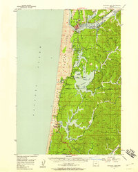 1956 Siltcoos Lake1958 Print · USGSThe Oregon coast in the mid-fifties reveals a landscape of massive dunes and rail-dependent timber towns. Researchers can trace the Southern Pacific line past Siltcoos and Westlake, or locate rural landmarks like Drew Cem and Ada Sta.3 unique versions available
 - 1958 Map of Coos Bay, 1974 Print
 1958 Coos Bay1974 Print · USGSThe Southern Oregon coastline at mid-century reveals a bustling maritime and timber economy centered on Coos Bay and North Bend. Researchers can trace the legacy of coastal settlements from Bandon to Brookings, including rail lines of the Southern Pacific RR and the rugged reaches of the Siuslaw National Forest.
End of results
Showing maps 1-6 of 6
Top cities near Florence
Frequently asked questions
- What are the different types of historical maps available for Florence?
- What is the oldest map of Florence?
- Where can I purchase historical maps of Florence for my home or office?
- Where can I download high-res historical maps of Florence?
- Are there historical topographic maps available for Florence?
- Is there historical aerial imagery available for Florence?
- Where are historical maps of Florence sourced from?