Old Maps of McKenzie Bridge, Oregon for Hiking & Exploration
Hike through history with 16 historic maps of McKenzie Bridge. Explore old trails, ghost towns, and forgotten backroads — perfect for outdoor adventurers and local explorers.
- Rediscover forgotten places: Map out old mining camps, roads, and footpaths that no longer exist on modern maps.
- Layer with modern tools: Combine with LiDAR or satellite views to plan hikes through historical terrain.
- Made for exploration: Popular among hikers, overlanders, and local history lovers.
Use these maps to find adventure and explore the hidden past of McKenzie Bridge.
McKenzie Bridge, OR maps
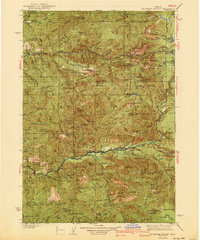
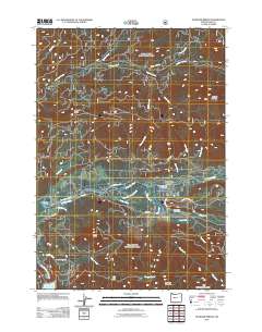
(16)- 1934 Map of Mc Kenzie Bridge
 1934 Mc Kenzie Bridge1934 Print · USGSThe Cascades in the mid-1930s were a network of forest guard stations, remote ranches, and early mountain resorts. Genealogists and historians can locate family landmarks such as Sims Ranch and Hardy Cabin or trace the early developments at Belknap Springs.
 - 1940 Map of Mc Kenzie Bridge
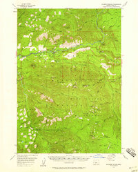
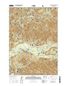
 1940 Mc Kenzie Bridge1940 Print · USGSThe Oregon Cascades during the late 1930s reveal a landscape of mining claims and early forest service outposts. Trace the locations of historic mineral sites like the Lucky Boy Mine, family homesteads at Cooks Ranch, and mountain retreats at Belknap Springs.3 unique versions available
 - 1953 Map of Salem
 1953 Salem1953 Print · USGSMid-century Oregon comes to life through this detailed survey of the Willamette Valley and the adjacent Pacific coastline. Researchers can trace the rail lines of the Southern Pacific RR, visit rural hubs like Fairview School, or locate coastal landmarks like the Yaquina Head Lighthouse.
 - 1954 Map of Salem
 1954 Salem1954 Print · USGSMid-century Western Oregon is centered on the productive Willamette River valley as its cities and infrastructure expand toward the mountains. Genealogists and historians can trace the rail lines of the Southern Pacific RR and Oregon Electric Ry through towns like Dallas, Independence, and Brownsville.
 - 1955 Map of Mc Kenzie Bridge, 1958 Print
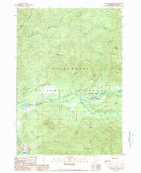
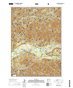
 1955 Mc Kenzie Bridge1958 Print · USGSThe McKenzie River valley in the mid-1950s shows a landscape of forest management and growing infrastructure. Genealogists and historians can trace the development of Cougar Dam and locate historic camps like Limberlost Forest Camp and Belknap Camp.3 unique versions available
 - 1960 Map of Salem, 1968 Print
 1960 Salem1968 Print · USGSThe Willamette Valley and the surrounding mountain ranges are shown here in the 1960s during a period of significant reservoir construction. Genealogists and historians can trace rail lines like the Oregon Electric and find communities from Lincoln City on the coast to Sweet Home and Mill City in the foothills.2 unique versions available
 - 1962 Map of Salem
 1962 Salem1962 Print · USGSThe Willamette Valley and the surrounding Oregon ranges are captured here in the early sixties, showing the vital growth of the state's primary agricultural and academic corridor. Researchers can trace the mid-century footprints of Oregon State University and the University of Oregon, alongside rural landmarks like Camp Adair and Black Butte Mine.
 - 1963 Map of Salem
 1963 Salem1963 Print · USGSMid-century Oregon comes into focus as the Willamette Valley’s timber and agricultural industries meet the growing campuses of Oregon State University and the University of Oregon. Researchers can trace old rail lines like the Oregon Electric Railway and locate family plots at Siletz Cem or Dallas Cem.
 - 1983 Map of Mc Kenzie River, 1984 Print
 1983 Mc Kenzie River1984 Print · USGSLinn and Lane Counties are shown in the early 1980s as a hub of hydroelectric power and timber production. Researchers can trace the development of river-valley towns like Sweet Home and Marcola or locate recreation sites at Foster Lake and Cougar Reservoir.
 - 1989 Map of Mc Kenzie Bridge
 1989 Mc Kenzie Bridge1989 Print · USGSThe McKenzie River valley in the late eighties serves as a gateway to the high Cascades, showcasing a landscape of timber and tourism. Researchers can trace historic river crossings at the Mc Kenzie Covered Bridge and find local landmarks like Castle Rock and Rainbow.
 - 1997 Map of Mc Kenzie Bridge, 2001 Print
 1997 Mc Kenzie Bridge2001 Print · USGSThe upper McKenzie River valley near Mc Kenzie Bridge and Rainbow comes into sharp focus during the late 1990s. Local historians can trace the development of hydroelectric power at Cougar Dam or locate historic river crossings like the Covered Bridge.
 - 2011 Map of McKenzie Bridge, 2011 Print
 2011 McKenzie Bridge2011 Print · USGSCovers McKenzie Bridge, including Rainbow, Lane County, and other nearby areas
 - 2014 Map of McKenzie Bridge, 2014 Print
 2014 McKenzie Bridge2014 Print · USGSCovers McKenzie Bridge, including Rainbow, Lane County, and other nearby areas
 - 2017 Map of McKenzie Bridge, 2017 Print
 2017 McKenzie Bridge2017 Print · USGSCovers McKenzie Bridge, including Rainbow, Lane County, and other nearby areas
 - 2020 Map of McKenzie Bridge, 2020 Print
 2020 McKenzie Bridge2020 Print · USGSCovers McKenzie Bridge, including Rainbow, Lane County, and other nearby areas
 - 2023 Map of McKenzie Bridge, 2023 Print
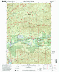
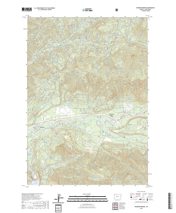 2023 McKenzie Bridge2023 Print · USGSThe McKenzie River valley comes alive in this contemporary record of the High Cascades, featuring the riverside settlements of McKenzie Bridge and Rainbow. Trace early forest travel routes and water resources from the Cougar Reservoir to the heights of Lookout Mtn.
End of results
Showing maps 1-16 of 16
Frequently asked questions
- What are the different types of historical maps available for McKenzie Bridge?
- What is the oldest map of McKenzie Bridge?
- Where can I purchase historical maps of McKenzie Bridge for my home or office?
- Where can I download high-res historical maps of McKenzie Bridge?
- Are there historical topographic maps available for McKenzie Bridge?
- Is there historical aerial imagery available for McKenzie Bridge?
- Where are historical maps of McKenzie Bridge sourced from?