Old Maps of Springfield, Oregon for Academic Research
Study the evolution of Springfield with 27 high-resolution historic maps. Whether you're teaching, researching, or modeling changes in land use, these maps provide essential visual documentation of urban, environmental, and geographic change.
- Analyze long-term change: Track patterns in development, transportation, and natural features.
- Ideal for environmental or urban studies: Support academic projects with primary historical map data.
- Use in the classroom or lab: Educators and researchers rely on these maps to bring historical context to life.
These maps are a powerful tool for teaching, research, and visualizing how Springfield has changed over the decades.
Springfield, OR maps
(27)- 1910 Map of Eugene
 1910 Eugene1910 Print · USGSThe upper Willamette Valley comes to life in the years before the Great War, centered on the growing campus of the University of Oregon. Genealogists can trace family footprints across dozens of local school districts like Santa Clara and Deadman, or follow the early tracks of the Oregon Electric RR.2 unique versions available
 - 1940 Map of Eugene
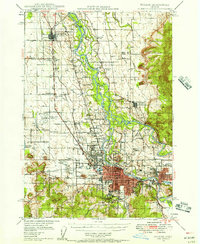
 1940 Eugene1940 Print · USGSThe Willamette Valley at the end of the Great Depression shows a landscape of growing towns and busy rail corridors. Genealogists can locate family-named landmarks like Gillespie Butte School and the I O O F Cemetery.2 unique versions available
 - 1946 Map of Eugene, 1957 Print
 1946 Eugene1957 Print · USGSThe Willamette Valley was a bustling corridor of rail and river commerce just after the war. Researchers can trace the development of Eugene and Springfield, locate family landmarks like the I O O F Cemetery, and follow the path of the Oregon Electric Railroad.2 unique versions available
 - 1949 Map of Eugene
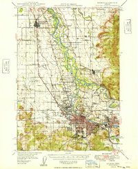 1949 Eugene1949 Print · USGSThe southern Willamette Valley thrived at mid-century as a rail and aviation hub connecting Junction City and Springfield. Researchers can trace old property lines through local landmarks like Lone Pine Sch and the I O O F Cemetery.
 - 1950 Map of Marcola, 1955 Print
 1950 Marcola1955 Print · USGSLane County in the early fifties shows a transition from timber-town economies to suburban growth near the McKenzie River. Researchers can locate family landmarks like the Camp Creek Cemetery, the Mohawk PO, and the rails of the Southern Pacific.2 unique versions available
 - 1952 Map of Marcola
 1952 Marcola1952 Print · USGSThe Mohawk River valley and McKenzie River corridor are captured here in the early fifties, showing the logging and rail infrastructure of eastern Lane County. Trace the SOUTHERN PACIFIC line through Wendling or locate family sites like Yarnell Church and Mt Vernon Cem.
 - 1953 Map of Salem
 1953 Salem1953 Print · USGSMid-century Oregon comes to life through this detailed survey of the Willamette Valley and the adjacent Pacific coastline. Researchers can trace the rail lines of the Southern Pacific RR, visit rural hubs like Fairview School, or locate coastal landmarks like the Yaquina Head Lighthouse.
 - 1954 Map of Salem
 1954 Salem1954 Print · USGSMid-century Western Oregon is centered on the productive Willamette River valley as its cities and infrastructure expand toward the mountains. Genealogists and historians can trace the rail lines of the Southern Pacific RR and Oregon Electric Ry through towns like Dallas, Independence, and Brownsville.
 - 1960 Map of Salem, 1968 Print
 1960 Salem1968 Print · USGSThe Willamette Valley and the surrounding mountain ranges are shown here in the 1960s during a period of significant reservoir construction. Genealogists and historians can trace rail lines like the Oregon Electric and find communities from Lincoln City on the coast to Sweet Home and Mill City in the foothills.2 unique versions available
 - 1962 Map of Salem
 1962 Salem1962 Print · USGSThe Willamette Valley and the surrounding Oregon ranges are captured here in the early sixties, showing the vital growth of the state's primary agricultural and academic corridor. Researchers can trace the mid-century footprints of Oregon State University and the University of Oregon, alongside rural landmarks like Camp Adair and Black Butte Mine.
 - 1963 Map of Salem
 1963 Salem1963 Print · USGSMid-century Oregon comes into focus as the Willamette Valley’s timber and agricultural industries meet the growing campuses of Oregon State University and the University of Oregon. Researchers can trace old rail lines like the Oregon Electric Railway and locate family plots at Siletz Cem or Dallas Cem.
 - 1967 Map of Eugene East
 1967 Eugene East1967 Print · USGSMid-century development transforms the Willamette Valley as the university and suburbs expand across the river plain. Researchers can locate specific sites from the University of Oregon, Autzen Stadium, and the Lane County Fairgrounds.3 unique versions available
 - 1967 Map of Springfield, 1969 Print
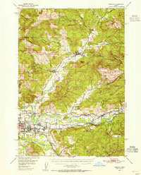
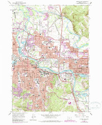
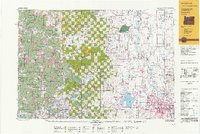
 1967 Springfield1969 Print · USGSSpringfield at the height of its mid-century growth is documented here as a major hub for rail and river activity. Genealogists and local historians can trace the foundations of neighborhoods around Hendricks, Thurston, and the historic Mt Vernon Cem.5 unique versions available
 - 1975 Map of Eugene East, 1979 Print
 1975 Eugene East1979 Print · USGSMid-seventies Lane County comes into focus in this detailed orthophoto showing the urban development of the upper Willamette Valley. Genealogists and local historians can trace the 1970s footprints of Eugene and Springfield along the Willamette River.
 - 1976 Map of Springfield, 1979 Print
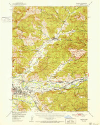
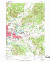
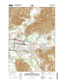
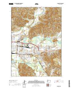
 1976 Springfield1979 Print · USGSSpringfield and its riverfront were entering a period of significant growth in the mid-seventies. Trace the shifting banks of the Mc Kenzie River and the winding Coast Fork Willamette River as they frame the city's expanding footprint.
 - 1980 Map of Eugene
 1980 Eugene1980 Print · USGSThe southern Willamette Valley and Coast Range are captured in the early eighties as the urban centers of Eugene and Springfield expanded. Researchers can trace the legacy of family estates and regional infrastructure through landmarks like Mahlon Sweet Airport, Fern Ridge Lake, and Junction City.
 - 1983 Map of Mc Kenzie River, 1984 Print
 1983 Mc Kenzie River1984 Print · USGSLinn and Lane Counties are shown in the early 1980s as a hub of hydroelectric power and timber production. Researchers can trace the development of river-valley towns like Sweet Home and Marcola or locate recreation sites at Foster Lake and Cougar Reservoir.
 - 1992 Map of Eugene
 1992 Eugene1992 Print · USGSThe Willamette Valley and Coast Range are captured in the early nineties, showing the growth of Eugene and Springfield. Researchers can trace timber history in the Siuslaw National Forest or locate valley settlements like Junction City and Harrisburg.
 - 2011 Map of Eugene East, 2011 Print
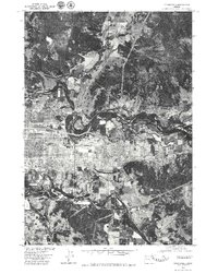
 2011 Eugene East2011 Print · USGSCovers Springfield, including Eugene, Lane County, and other nearby areas
 - 2011 Map of Springfield, 2011 Print
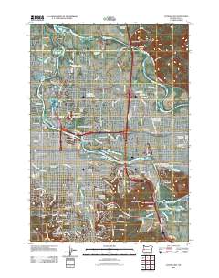
 2011 Springfield2011 Print · USGSCovers Springfield, including Lane County, United States, and other nearby areas
 - 2014 Map of Springfield, 2014 Print
 2014 Springfield2014 Print · USGSCovers Springfield, including Lane County, United States, and other nearby areas
 - 2014 Map of Eugene East, 2014 Print
 2014 Eugene East2014 Print · USGSCovers Springfield, including Eugene, Lane County, and other nearby areas
 - 2017 Map of Springfield, 2017 Print
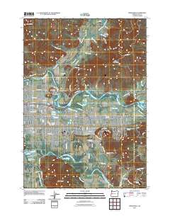
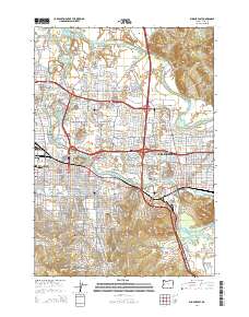
 2017 Springfield2017 Print · USGSCovers Springfield, including Lane County, United States, and other nearby areas
 - 2020 Map of Springfield, 2020 Print
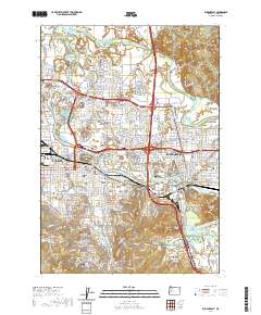
 2020 Springfield2020 Print · USGSCovers Springfield, including Lane County, United States, and other nearby areas
 - 2020 Map of Eugene East, 2020 Print
 2020 Eugene East2020 Print · USGSCovers Springfield, including Eugene, Lane County, and other nearby areas
Showing maps 1-25 of 27
Top cities near Springfield
- Eugene historical maps
- Junction City historical maps
- Creswell historical maps
- Harrisburg historical maps
- Coburg historical maps
- Lowell historical maps
Top neighborhoods of Springfield
Frequently asked questions
- What are the different types of historical maps available for Springfield?
- What is the oldest map of Springfield?
- Where can I purchase historical maps of Springfield for my home or office?
- Where can I download high-res historical maps of Springfield?
- Are there historical topographic maps available for Springfield?
- Is there historical aerial imagery available for Springfield?
- Where are historical maps of Springfield sourced from?