1980s Maps of Tiernan, Oregon
Explore 2 historic maps of Tiernan from the 1980s. These maps offer a rare glimpse into what life looked like during the 1980s — showing old roads, neighborhoods, homes, and landmarks that have changed or disappeared over time.
Whether you're researching your family's past, planning a metal detecting trip, or studying how Tiernan's landscape evolved across the 1980s, these high-resolution maps are a powerful tool for exploring the history of this region.
- Focus on a specific era: All maps on this page are from the 1980s, giving you a focused view of this time period.
- See what’s changed: Compare century-old streets, trails, and buildings to today's modern landscape using overlays and satellite layers.
- Research with precision: Use these maps for genealogy, historical research, land use analysis, or educational projects.
- View, download, or print: Maps are fully viewable online in high resolution, and can be downloaded or printed for your own records.
Start exploring Tiernan's history through authentic maps from the 1980s. This is your window into the past.
Tiernan, OR maps
(2)- 1980 Map of Eugene
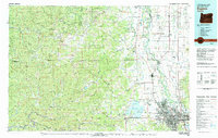 1980 Eugene1980 Print · USGSThe southern Willamette Valley and Coast Range are captured in the early eighties as the urban centers of Eugene and Springfield expanded. Researchers can trace the legacy of family estates and regional infrastructure through landmarks like Mahlon Sweet Airport, Fern Ridge Lake, and Junction City.
 - 1984 Map of Tiernan
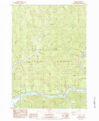 1984 Tiernan1984 Print · USGSThe Siuslaw River valley in the mid-1980s reveals a landscape defined by timber, tide, and the rails. Researchers can trace the riverfront rail stops at Tiernan and Beck Station, locate old homestead sites near Brickerville, or explore the drainages of Sweet Creek and Hanson Ridge.
End of results
Showing maps 1-2 of 2
Top cities near Tiernan
Frequently asked questions
- What are the different types of historical maps available for Tiernan?
- What is the oldest map of Tiernan?
- Where can I purchase historical maps of Tiernan for my home or office?
- Where can I download high-res historical maps of Tiernan?
- Are there historical topographic maps available for Tiernan?
- Is there historical aerial imagery available for Tiernan?
- Where are historical maps of Tiernan sourced from?