Old Maps of Cascadia, Oregon
Explore 15 old maps of Cascadia, spanning from 1934 to today. These high-resolution historic maps reveal how streets, neighborhoods, landmarks, and natural features evolved over time — perfect for genealogy, metal detecting, research, and local history exploration.
What you can do with these maps:
- See how Cascadia changed over time: Compare historical maps to modern-day views to trace roads, homesites, rail lines & more.
- View detailed metadata: Each map includes creators, publishers, year, scale, and archive source.
- Overlay maps with satellite & LiDAR: Visualize the past alongside modern tools to explore terrain & human change.
- Trusted historical sources: Maps sourced from the USGS, Library of Congress, and other archives.
- Access maps your way: View online, download high-res files, or order prints for personal or research use.
Start exploring old maps of Cascadia to uncover forgotten places, hidden landmarks, and the deep history beneath your feet.
Cascadia, OR maps
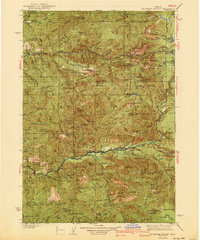
(15)- 1934 Map of Mc Kenzie Bridge
 1934 Mc Kenzie Bridge1934 Print · USGSThe Cascades in the mid-1930s were a network of forest guard stations, remote ranches, and early mountain resorts. Genealogists and historians can locate family landmarks such as Sims Ranch and Hardy Cabin or trace the early developments at Belknap Springs.
 - 1940 Map of Mc Kenzie Bridge
 1940 Mc Kenzie Bridge1940 Print · USGSThe Oregon Cascades during the late 1930s reveal a landscape of mining claims and early forest service outposts. Trace the locations of historic mineral sites like the Lucky Boy Mine, family homesteads at Cooks Ranch, and mountain retreats at Belknap Springs.3 unique versions available
 - 1953 Map of Salem
 1953 Salem1953 Print · USGSMid-century Oregon comes to life through this detailed survey of the Willamette Valley and the adjacent Pacific coastline. Researchers can trace the rail lines of the Southern Pacific RR, visit rural hubs like Fairview School, or locate coastal landmarks like the Yaquina Head Lighthouse.
 - 1954 Map of Salem
 1954 Salem1954 Print · USGSMid-century Western Oregon is centered on the productive Willamette River valley as its cities and infrastructure expand toward the mountains. Genealogists and historians can trace the rail lines of the Southern Pacific RR and Oregon Electric Ry through towns like Dallas, Independence, and Brownsville.
 - 1955 Map of Cascadia, 1958 Print
 1955 Cascadia1958 Print · USGSThe South Santiam River corridor near Cascadia is documented here in the mid-1950s, showing a landscape of forest camps and mountain lookouts. Genealogists and hikers can trace early access roads to Upper Soda, Rainbow Falls, and the high ridges of Moose Ridge.3 unique versions available
 - 1960 Map of Salem, 1968 Print
 1960 Salem1968 Print · USGSThe Willamette Valley and the surrounding mountain ranges are shown here in the 1960s during a period of significant reservoir construction. Genealogists and historians can trace rail lines like the Oregon Electric and find communities from Lincoln City on the coast to Sweet Home and Mill City in the foothills.2 unique versions available
 - 1962 Map of Salem
 1962 Salem1962 Print · USGSThe Willamette Valley and the surrounding Oregon ranges are captured here in the early sixties, showing the vital growth of the state's primary agricultural and academic corridor. Researchers can trace the mid-century footprints of Oregon State University and the University of Oregon, alongside rural landmarks like Camp Adair and Black Butte Mine.
 - 1963 Map of Salem
 1963 Salem1963 Print · USGSMid-century Oregon comes into focus as the Willamette Valley’s timber and agricultural industries meet the growing campuses of Oregon State University and the University of Oregon. Researchers can trace old rail lines like the Oregon Electric Railway and locate family plots at Siletz Cem or Dallas Cem.
 - 1983 Map of Mc Kenzie River, 1984 Print
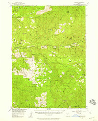
 1983 Mc Kenzie River1984 Print · USGSLinn and Lane Counties are shown in the early 1980s as a hub of hydroelectric power and timber production. Researchers can trace the development of river-valley towns like Sweet Home and Marcola or locate recreation sites at Foster Lake and Cougar Reservoir.
 - 1985 Map of Cascadia
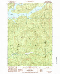 1985 Cascadia1985 Print · USGSLinn County in the mid-1980s shows a landscape of deep river canyons and forest management near the community of Cascadia. Trace the winding South Fork Santiam River to find local landmarks like Soda Spring, Rainbow Falls, and the shorelines of Green Peter Lake.
 - 1994 Map of Cascadia, 1998 Print
 1994 Cascadia1998 Print · USGSLinn County during the 1990s shows a landscape defined by the Santiam corridor and the expansive waters of Green Peter Lake. Genealogists and historians can trace the Old Santiam Road and locate sites like the Whitcomb Cem and the mineral waters of Soda Spring.
 - 2014 Map of Cascadia, 2014 Print
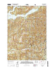 2014 Cascadia2014 Print · USGSCovers Cascadia, including Linn County, United States, and other nearby areas
 - 2017 Map of Cascadia, 2017 Print
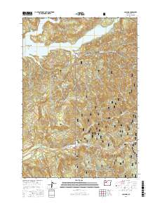 2017 Cascadia2017 Print · USGSCovers Cascadia, including Linn County, United States, and other nearby areas
 - 2020 Map of Cascadia, 2020 Print
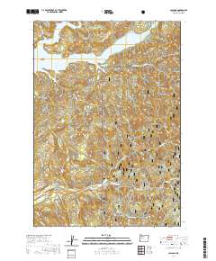 2020 Cascadia2020 Print · USGSCovers Cascadia, including Linn County, United States, and other nearby areas
 - 2024 Map of Cascadia, 2024 Print
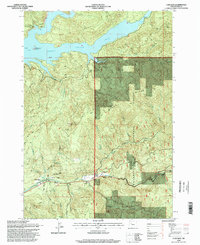
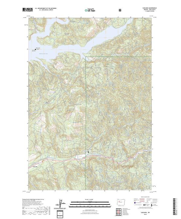 2024 Cascadia2024 Print · USGSCascadia and the Santiam river valleys are shown in this contemporary study of Linn County. Researchers can locate the Whitcomb Island Cem or trace mountain drainages like Wolf Creek and Moose Creek.
End of results
Showing maps 1-15 of 15
Top cities near Cascadia
Frequently asked questions
- What are the different types of historical maps available for Cascadia?
- What is the oldest map of Cascadia?
- Where can I purchase historical maps of Cascadia for my home or office?
- Where can I download high-res historical maps of Cascadia?
- Are there historical topographic maps available for Cascadia?
- Is there historical aerial imagery available for Cascadia?
- Where are historical maps of Cascadia sourced from?