1920s Maps of Crabtree, Oregon
Explore 3 historic maps of Crabtree from the 1920s. These maps offer a rare glimpse into what life looked like during the 1920s — showing old roads, neighborhoods, homes, and landmarks that have changed or disappeared over time.
Whether you're researching your family's past, planning a metal detecting trip, or studying how Crabtree's landscape evolved across the 1920s, these high-resolution maps are a powerful tool for exploring the history of this region.
- Focus on a specific era: All maps on this page are from the 1920s, giving you a focused view of this time period.
- See what’s changed: Compare century-old streets, trails, and buildings to today's modern landscape using overlays and satellite layers.
- Research with precision: Use these maps for genealogy, historical research, land use analysis, or educational projects.
- View, download, or print: Maps are fully viewable online in high resolution, and can be downloaded or printed for your own records.
Start exploring Crabtree's history through authentic maps from the 1920s. This is your window into the past.
Crabtree, OR maps
(3)- 1921 Map of Lebanon
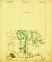 1921 Lebanon1921 Print · USGSLinn County at the dawn of the 1920s reveals a landscape of thriving rural schools and expanding rail lines. Trace family roots and early farmstead locations near Lebanon, Tallman, and the South Santiam River.
 - 1922 Map of Lebanon
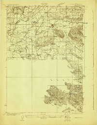 1922 Lebanon1922 Print · USGSLinn County during the early 1920s reveals a landscape of river-fed farms and burgeoning rail towns. Genealogists and historians can locate dozens of country schoolhouses like Cole School and family landmarks such as Ballins Mill and Miller Cemetery.
 - 1924 Map of Lebanon
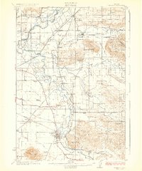 1924 Lebanon1924 Print · USGSLinn County agriculture and rail life are captured here in the early twenties as small communities flourished along the river forks. Researchers can trace the exact locations of many rural schoolhouses like Happy Home School and old mill sites such as Ballins Mill.3 unique versions available
End of results
Showing maps 1-3 of 3
Top cities near Crabtree
- Salem historical maps
- Albany historical maps
- Lebanon historical maps
- Sweet Home historical maps
- Stayton historical maps
- Aumsville historical maps
See more
Frequently asked questions
- What are the different types of historical maps available for Crabtree?
- What is the oldest map of Crabtree?
- Where can I purchase historical maps of Crabtree for my home or office?
- Where can I download high-res historical maps of Crabtree?
- Are there historical topographic maps available for Crabtree?
- Is there historical aerial imagery available for Crabtree?
- Where are historical maps of Crabtree sourced from?