1900s (20th Century) Maps of Basque, Oregon
Explore 5 historic maps of Basque from the 1900s (20th Century). These maps offer a rare glimpse into what life looked like during the 1900s — showing old roads, neighborhoods, homes, and landmarks that have changed or disappeared over time.
Whether you're researching your family's past, planning a metal detecting trip, or studying how Basque's landscape evolved across the 1900s, these high-resolution maps are a powerful tool for exploring the history of this region.
- Focus on a specific era: All maps on this page are from the 1900s, giving you a focused view of this time period.
- See what’s changed: Compare century-old streets, trails, and buildings to today's modern landscape using overlays and satellite layers.
- Research with precision: Use these maps for genealogy, historical research, land use analysis, or educational projects.
- View, download, or print: Maps are fully viewable online in high resolution, and can be downloaded or printed for your own records.
Start exploring Basque's history through authentic maps from the 1900s. This is your window into the past.
Basque, OR maps
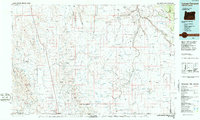
(5)- 1955 Map of Jordan Valley, 1963 Print
 1955 Jordan Valley1963 Print · USGSThe high desert of Malheur County comes alive in the mid-1950s, showing the isolated ranching outposts and deep canyons along the Idaho border. Researchers can trace the remote reaches of the Owyhee River, the cattle town of Jordan Valley, and mining landmarks like War Eagle Mountain.3 unique versions available
 - 1957 Map of Jordan Valley
 1957 Jordan Valley1957 Print · USGSThe high-desert borderlands of Oregon and Idaho appear in the mid-fifties as a world of remote cattle ranches and mining claims. Researchers can trace historic family-named locations like Bowden Ranch and Riddle alongside the South Mountain Mining Company.
 - 1958 Map of Jordan Valley
 1958 Jordan Valley1958 Print · USGSSoutheast Oregon and Southwest Idaho are documented here during the mid-fifties, showing a landscape of remote cattle ranches and volcanic badlands. Genealogists and historians can trace family operations like the Bowden Ranch or locate the Pleasant Valley School and the South Mountain Mining Company.2 unique versions available
 - 1982 Map of Basque, 1983 Print
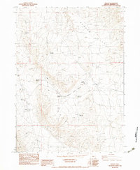 1982 Basque1983 Print · USGSIn the high desert of Malheur County during the early 1980s, the remote outpost of Basque served as a focal point for regional water and resource management. Researchers can trace land use patterns through numerous named catchments like Bad News Reservoir and landmarks such as Overshoe Well.
 - 1984 Map of Louse Canyon, 1986 Print
 1984 Louse Canyon1986 Print · USGSThe high-desert borderlands of Oregon, Nevada, and Idaho are shown here in the mid-1980s. Local researchers can trace the Owyhee River canyons and find remote landmarks like McDermitt, the Schoolhouse, and the Fort Mcdermitt Indian Reservation.
End of results
Showing maps 1-5 of 5
Frequently asked questions
- What are the different types of historical maps available for Basque?
- What is the oldest map of Basque?
- Where can I purchase historical maps of Basque for my home or office?
- Where can I download high-res historical maps of Basque?
- Are there historical topographic maps available for Basque?
- Is there historical aerial imagery available for Basque?
- Where are historical maps of Basque sourced from?