1900s (20th Century) Maps of Westfall, Oregon
Explore 6 historic maps of Westfall from the 1900s (20th Century). These maps offer a rare glimpse into what life looked like during the 1900s — showing old roads, neighborhoods, homes, and landmarks that have changed or disappeared over time.
Whether you're researching your family's past, planning a metal detecting trip, or studying how Westfall's landscape evolved across the 1900s, these high-resolution maps are a powerful tool for exploring the history of this region.
- Focus on a specific era: All maps on this page are from the 1900s, giving you a focused view of this time period.
- See what’s changed: Compare century-old streets, trails, and buildings to today's modern landscape using overlays and satellite layers.
- Research with precision: Use these maps for genealogy, historical research, land use analysis, or educational projects.
- View, download, or print: Maps are fully viewable online in high resolution, and can be downloaded or printed for your own records.
Start exploring Westfall's history through authentic maps from the 1900s. This is your window into the past.
Westfall, OR maps
(6)- 1955 Map of Boise, 1977 Print
 1955 Boise1977 Print · USGSThe Treasure Valley and Owyhee uplands are shown in detail during the mid-fifties, capturing the region's transition into a major agricultural and urban hub. Researchers can trace the Union Pacific line through Nampa, explore the volcanic Jordan Craters, or locate the historic mining district of Silver City.
 - 1958 Map of Boise
 1958 Boise1958 Print · USGSThe Treasure Valley and Snake River Plain come alive in the mid-fifties as the rail-and-river economy transitions into a modern agricultural hub. Trace the Union Pacific lines through Nampa or locate remote landmarks like Initial Point and the Rockville settlement.2 unique versions available
 - 1962 Map of Boise
 1962 Boise1962 Print · USGSThe Treasure Valley at the start of the sixties reveals a landscape of expanding towns and complex irrigation networks along the Snake River. Genealogists and historians can trace the foundations of modern Idaho through markers like Initial Point, the mining history of Silver City, and the early infrastructure of Lucky Peak Dam.
 - 1966 Map of Harper, 1968 Print
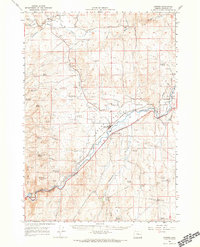 1966 Harper1968 Print · USGSEastern Oregon ranching and rail infrastructure define this mid-century portrait of Malheur County. Researchers can trace the Union Pacific line through Harper and locate remote landmarks like Westfall, Buckaroo Cabin, and the Cem near Bully Creek.
 - 1990 Map of Westfall
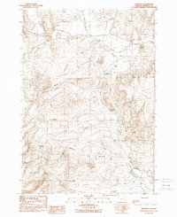 1990 Westfall1990 Print · USGSThe settlement of Westfall and a preserved segment of the Oregon Trail define this corner of Malheur County in the late twentieth century. Researchers can trace historic water routes and pioneer paths through landmarks like Zimmerman Ditch, Cemetery Spring, and the Open Pit Mines.
 - 1993 Map of Vale
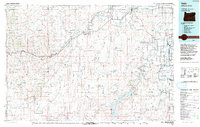 1993 Vale1993 Print · USGSEastern Oregon's river valleys and high desert plateaus are captured here in the early nineties, centered on the irrigation-rich lands of Malheur County. Researchers can locate the Miller Memorial Airpark, follow the Union Pacific rails, and trace the Owyhee River past Mitchell Butte.2 unique versions available
End of results
Showing maps 1-6 of 6
Frequently asked questions
- What are the different types of historical maps available for Westfall?
- What is the oldest map of Westfall?
- Where can I purchase historical maps of Westfall for my home or office?
- Where can I download high-res historical maps of Westfall?
- Are there historical topographic maps available for Westfall?
- Is there historical aerial imagery available for Westfall?
- Where are historical maps of Westfall sourced from?