1980s Maps of Mill City, Oregon
Explore 3 historic maps of Mill City from the 1980s. These maps offer a rare glimpse into what life looked like during the 1980s — showing old roads, neighborhoods, homes, and landmarks that have changed or disappeared over time.
Whether you're researching your family's past, planning a metal detecting trip, or studying how Mill City's landscape evolved across the 1980s, these high-resolution maps are a powerful tool for exploring the history of this region.
- Focus on a specific era: All maps on this page are from the 1980s, giving you a focused view of this time period.
- See what’s changed: Compare century-old streets, trails, and buildings to today's modern landscape using overlays and satellite layers.
- Research with precision: Use these maps for genealogy, historical research, land use analysis, or educational projects.
- View, download, or print: Maps are fully viewable online in high resolution, and can be downloaded or printed for your own records.
Start exploring Mill City's history through authentic maps from the 1980s. This is your window into the past.
Mill City, OR maps
(3)- 1983 Map of North Santiam River, 1984 Print
 1983 North Santiam River1984 Print · USGSThe western Cascades and Willamette Valley transition in the early eighties, from the state capital to the high timberlands. Genealogists and historians can trace rail lines like the Southern Pacific and explore communities from Mill City to Silver Falls City.
 - 1985 Map of Mill City South
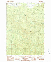 1985 Mill City South1985 Print · USGSLinn County forest lands are captured in the mid-1980s as timber and industry shaped the landscape south of the Santiam River. Researchers can trace rural cemeteries and sites like Turnidge, or locate remote landmarks like the Landing Strip and High Rock.
 - 1985 Map of Mill City North
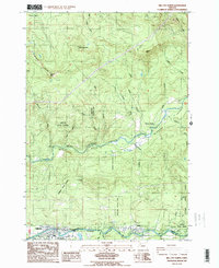 1985 Mill City North1985 Print · USGSMarion and Linn counties meet along the river in the mid-1980s as timber and recreation define the local economy. Researchers can trace the development of riverside settlements like Mill City and Gates, or locate family sites near Bear Creek Park and Minto.2 unique versions available
End of results
Showing maps 1-3 of 3
Top cities near Mill City
Frequently asked questions
- What are the different types of historical maps available for Mill City?
- What is the oldest map of Mill City?
- Where can I purchase historical maps of Mill City for my home or office?
- Where can I download high-res historical maps of Mill City?
- Are there historical topographic maps available for Mill City?
- Is there historical aerial imagery available for Mill City?
- Where are historical maps of Mill City sourced from?