1970s Maps of Multnomah County, Oregon
Explore 11 historic maps of Multnomah County from the 1970s. These maps offer a rare glimpse into what life looked like during the 1970s — showing old roads, neighborhoods, homes, and landmarks that have changed or disappeared over time.
Whether you're researching your family's past, planning a metal detecting trip, or studying how Multnomah County's landscape evolved across the 1970s, these high-resolution maps are a powerful tool for exploring the history of this region.
- Focus on a specific era: All maps on this page are from the 1970s, giving you a focused view of this time period.
- See what’s changed: Compare century-old streets, trails, and buildings to today's modern landscape using overlays and satellite layers.
- Research with precision: Use these maps for genealogy, historical research, land use analysis, or educational projects.
- View, download, or print: Maps are fully viewable online in high resolution, and can be downloaded or printed for your own records.
Start exploring Multnomah County's history through authentic maps from the 1970s. This is your window into the past.
Multnomah County, OR maps
(11)- 1975 Map of Camas, 1977 Print
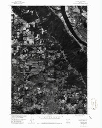
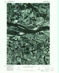 1975 Camas1977 Print · USGSMid-seventies development along the Columbia River waterfront is captured here just as suburban growth began to transform the landscape. Researchers can trace the mid-century footprints of Camas, Rockwood, and the northern edge of Gresham.
 - 1975 Map of Gladstone, 1977 Print
 1975 Gladstone1977 Print · USGSGreater Portland and the riverside communities of Clackamas County are captured in high-detail aerial imagery during the mid-seventies. Researchers can trace the development of Gladstone near the Willamette River or study the terrain around Mount Scott.
 - 1975 Map of Mount Tabor, 1977 Print
 1975 Mount Tabor1977 Print · USGSThe Columbia River corridor and the growing metro areas of the mid-seventies come into sharp focus through this aerial-imagery orthophotoquad. Researchers can trace the development of Portland and Vancouver, from the slopes of Mount Tabor to the runways of Portland International Airport.
 - 1975 Map of Portland, 1979 Print
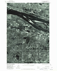
 1975 Portland1979 Print · USGSGreater Portland and Vancouver are captured mid-decade in this detailed 1970s aerial survey. Trace the industrial waterfronts, residential grids, and the distinct elevation of Sylvan as they appeared just before years of modern redevelopment.2 unique versions available
 - 1975 Map of Linnton, 1979 Print
 1975 Linnton1979 Print · USGSThe Willamette River industrial corridor and emerging suburbs are shown in this mid-1970s aerial survey during a period of significant expansion. Trace the historical development of Linnton, St Johns, and the residential patterns in Aloha.
 - 1975 Map of Damascus, 1985 Print
 1975 Damascus1985 Print · USGSClackamas County is captured in the mid-1970s as a patchwork of timber and farmland during a period of steady rural growth. Researchers can trace the development of Damascus and Boring while examining the wooded slopes of Walters Hill.
 - 1976 Map of Mount Tabor, 1981 Print
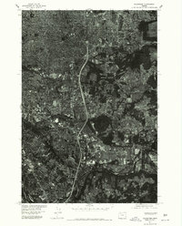
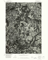
 1976 Mount Tabor1981 Print · USGSThe eastern neighborhoods of Portland and the volcanic peak of Mount Tabor are seen with photographic precision in the mid-1970s. This aerial record allows you to trace the exact layout of residential blocks and industrial zones near Portland during a period of significant urban density.
 - 1979 Map of Bonneville Dam
 1979 Bonneville Dam1979 Print · USGSThe Columbia River Gorge in the late seventies reveals a landscape of massive hydroelectric works and timbered peaks. Genealogists and historians can trace the riverside towns of Stevenson and Cascade Locks or locate the site of the Bonneville Dam.
 - 1979 Map of Wahtum Lake, 1980 Print
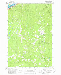
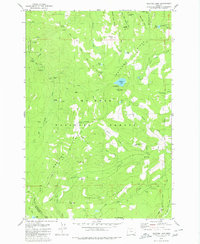 1979 Wahtum Lake1980 Print · USGSThe high ridges of the Cascades are documented here in the late seventies, detailing the extensive backcountry trail network of the Mount Hood National Forest. Hikers and historians can trace the Pacific Crest National Scenic Trail past Wahtum Lake and find remote sites like Indian Springs Campground and Wy'East Campsite.2 unique versions available
 - 1979 Map of Vancouver, 1980 Print
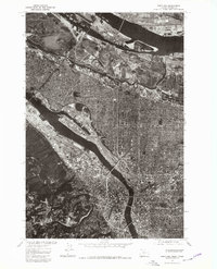
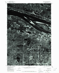
 1979 Vancouver1980 Print · USGSThe Portland and Vancouver metropolitan area is captured here in the late seventies, showing the dense nexus of river, rail, and air transit. Genealogists and local historians can trace the footprints of Vancouver Barracks, Lincoln Memorial Park Cem, and the old rail lines of the Burlington Northern.2 unique versions available
 - 1979 Map of Tanner Butte, 1980 Print
 1979 Tanner Butte1980 Print · USGSThe wilderness of the Columbia River Gorge in the late seventies reveals a landscape of waterfalls and timberlands. Outdoor enthusiasts and researchers can trace the Union Pacific rail line, find remote mountain camps at Tenas Camp Falls, and locate summits like Tanner Butte and Mt Talapus.2 unique versions available
End of results
Showing maps 1-11 of 11
Top cities of Multnomah County
- Portland historical maps
- Gresham historical maps
- Springdale historical maps
- Troutdale historical maps
- Fairview historical maps
- Wood Village historical maps
See more
Frequently asked questions
- What are the different types of historical maps available for Multnomah County?
- What is the oldest map of Multnomah County?
- Where can I purchase historical maps of Multnomah County for my home or office?
- Where can I download high-res historical maps of Multnomah County?
- Are there historical topographic maps available for Multnomah County?
- Is there historical aerial imagery available for Multnomah County?
- Where are historical maps of Multnomah County sourced from?