1980s Maps of Multnomah County, Oregon
Explore 7 historic maps of Multnomah County from the 1980s. These maps offer a rare glimpse into what life looked like during the 1980s — showing old roads, neighborhoods, homes, and landmarks that have changed or disappeared over time.
Whether you're researching your family's past, planning a metal detecting trip, or studying how Multnomah County's landscape evolved across the 1980s, these high-resolution maps are a powerful tool for exploring the history of this region.
- Focus on a specific era: All maps on this page are from the 1980s, giving you a focused view of this time period.
- See what’s changed: Compare century-old streets, trails, and buildings to today's modern landscape using overlays and satellite layers.
- Research with precision: Use these maps for genealogy, historical research, land use analysis, or educational projects.
- View, download, or print: Maps are fully viewable online in high resolution, and can be downloaded or printed for your own records.
Start exploring Multnomah County's history through authentic maps from the 1980s. This is your window into the past.
Multnomah County, OR maps
(7)- 1982 Map of Hood River, 1983 Print
 1982 Hood River1983 Print · USGSThe Columbia River Gorge in the early eighties shows a landscape shaped by massive hydroelectric projects and deep-rooted timber communities. Researchers can trace the rail-and-river network through Cascade Locks and The Dalles Dam, or explore the terrain of Gifford Pinchot National Forest.
 - 1982 Map of Oregon City, 1983 Print
 1982 Oregon City1983 Print · USGSGreater Portland and the Willamette Valley are shown in the early eighties as the region's urban and rural landscapes converged. Genealogists and historians can trace family-named sites across French Prairie, visit St Paul Ch, or locate the grounds of Dammasch State Hospital.
 - 1983 Map of Mount Hood
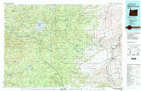 1983 Mount Hood1983 Print · USGSMount Hood and its surrounding national forest are captured here in the early eighties, spanning from alpine glaciers to the high desert plains. Genealogists and historians can trace old routes like the Barlow Road and locate remote landmarks like Bear Springs Ranger Sta or the settlement of Tygh Valley.
 - 1985 Map of Bull Run, 1986 Print
 1985 Bull Run1986 Print · USGSClackamas County was a hub of water management and rural settlement in the mid-1980s, centered on the protected forest watersheds. Researchers can trace the layout of historic sites like Bull Run, the local Cem, and recreational landmarks such as Camp Namanu.2 unique versions available
 - 1986 Map of Multnomah Falls
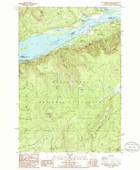 1986 Multnomah Falls1986 Print · USGSThe Columbia River Gorge in the mid-eighties shows a landscape of dramatic cataracts and vital transit routes. Trace the historic paths between Skamania Landing and Warrendale, or locate landmarks like Multnomah Falls and the towering Saint Peters Dome.2 unique versions available
 - 1986 Map of Brightwood
 1986 Brightwood1986 Print · USGSMount Hood’s western foothills in the 1980s are defined here by the critical water infrastructure of the Bull Run River. Genealogists and local historians can trace the riverside communities of Brightwood and Marmot or locate the remote Township Meadow.
 - 1986 Map of Bridal Veil
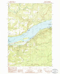 1986 Bridal Veil1986 Print · USGSThe Columbia River Gorge in the mid-1980s reveals a landscape of dramatic riverside cliffs and historic parklands. Researchers can trace the development of riverfront settlements like Prindle and Bridal Veil or locate landmarks like Rooster Rock and the Pillars of Hercules.2 unique versions available
End of results
Showing maps 1-7 of 7
Top cities of Multnomah County
- Portland historical maps
- Gresham historical maps
- Springdale historical maps
- Troutdale historical maps
- Fairview historical maps
- Wood Village historical maps
See more
Frequently asked questions
- What are the different types of historical maps available for Multnomah County?
- What is the oldest map of Multnomah County?
- Where can I purchase historical maps of Multnomah County for my home or office?
- Where can I download high-res historical maps of Multnomah County?
- Are there historical topographic maps available for Multnomah County?
- Is there historical aerial imagery available for Multnomah County?
- Where are historical maps of Multnomah County sourced from?