1960s Maps of Pilot Rock, Oregon
Explore 2 historic maps of Pilot Rock from the 1960s. These maps offer a rare glimpse into what life looked like during the 1960s — showing old roads, neighborhoods, homes, and landmarks that have changed or disappeared over time.
Whether you're researching your family's past, planning a metal detecting trip, or studying how Pilot Rock's landscape evolved across the 1960s, these high-resolution maps are a powerful tool for exploring the history of this region.
- Focus on a specific era: All maps on this page are from the 1960s, giving you a focused view of this time period.
- See what’s changed: Compare century-old streets, trails, and buildings to today's modern landscape using overlays and satellite layers.
- Research with precision: Use these maps for genealogy, historical research, land use analysis, or educational projects.
- View, download, or print: Maps are fully viewable online in high resolution, and can be downloaded or printed for your own records.
Start exploring Pilot Rock's history through authentic maps from the 1960s. This is your window into the past.
Pilot Rock, OR maps
(2)- 1966 Map of Mc Kay Reservoir, 1967 Print
 1966 Mc Kay Reservoir1967 Print · USGSUmatilla County in the mid-1960s centers on the critical water resources and rail corridors that defined eastern Oregon's development. Genealogists and historians can trace the Old Indian Treaty Boundary and locate landmarks like the White Eagle Grange Hall and Mckay Creek Cem.
 - 1967 Map of Pilot Rock, 1970 Print
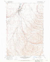 1967 Pilot Rock1970 Print · USGSPilot Rock was a central rail and water hub in Umatilla County during the late sixties. Genealogists and historians can locate the Pilot Rock Cem, trace the Old Indian Treaty Boundary, and find infrastructure like the High Sch and Landing Strip.
End of results
Showing maps 1-2 of 2
Top cities near Pilot Rock
Frequently asked questions
- What are the different types of historical maps available for Pilot Rock?
- What is the oldest map of Pilot Rock?
- Where can I purchase historical maps of Pilot Rock for my home or office?
- Where can I download high-res historical maps of Pilot Rock?
- Are there historical topographic maps available for Pilot Rock?
- Is there historical aerial imagery available for Pilot Rock?
- Where are historical maps of Pilot Rock sourced from?