Old Maps of Pilot Rock, Oregon for Academic Research
Study the evolution of Pilot Rock with 13 high-resolution historic maps. Whether you're teaching, researching, or modeling changes in land use, these maps provide essential visual documentation of urban, environmental, and geographic change.
- Analyze long-term change: Track patterns in development, transportation, and natural features.
- Ideal for environmental or urban studies: Support academic projects with primary historical map data.
- Use in the classroom or lab: Educators and researchers rely on these maps to bring historical context to life.
These maps are a powerful tool for teaching, research, and visualizing how Pilot Rock has changed over the decades.
Pilot Rock, OR maps
(13)- 1935 Map of Pendleton
 1935 Pendleton1935 Print · USGSPendleton and the surrounding Umatilla River valley are captured in the mid-1930s as the region solidified its role as a transportation and agricultural hub. Genealogists can locate numerous named rural schoolhouses such as Campbell Sch and North Yoakum Sch, or trace family sites near the Umatilla Indian Reservation and Cabbage Hill.3 unique versions available
 - 1953 Map of Pendleton, 1957 Print
 1953 Pendleton1957 Print · USGSNortheastern Oregon and the Columbia River frontier are captured here in the early fifties, a time of massive federal infrastructure projects. Researchers can trace the historic route of The Old Oregon Trail as it passes near the Umatilla Ordnance Depot and the new McNary Dam.4 unique versions available
 - 1956 Map of Pendleton
 1956 Pendleton1956 Print · USGSNortheastern Oregon’s high plateau and timbered peaks appear here in the mid-fifties, during a time of major military and hydroelectric development. Trace the path of The Old Oregon Trail alongside modern landmarks like McNary Dam and the Umatilla Ordnance Depot.
 - 1966 Map of Mc Kay Reservoir, 1967 Print
 1966 Mc Kay Reservoir1967 Print · USGSUmatilla County in the mid-1960s centers on the critical water resources and rail corridors that defined eastern Oregon's development. Genealogists and historians can trace the Old Indian Treaty Boundary and locate landmarks like the White Eagle Grange Hall and Mckay Creek Cem.
 - 1967 Map of Pilot Rock, 1970 Print
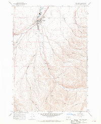 1967 Pilot Rock1970 Print · USGSPilot Rock was a central rail and water hub in Umatilla County during the late sixties. Genealogists and historians can locate the Pilot Rock Cem, trace the Old Indian Treaty Boundary, and find infrastructure like the High Sch and Landing Strip.
 - 1979 Map of La Grande, 1980 Print
 1979 La Grande1980 Print · USGSNorthwestern Oregon’s mountain corridors are captured here in the late seventies, showing the rail and river networks through the Blue Mountains. Trace the Old Emigrant Road, locate the Aurelia Mine, or explore the Starkey Experimental Forest.2 unique versions available
 - 1983 Map of Pendleton, 1984 Print
 1983 Pendleton1984 Print · USGSPendleton and the Blue Mountain foothills are captured here in the early eighties as a hub of rail, ranching, and forest management. Genealogists and historians can trace local landmarks like Indian Agency Hdqrs, Bingham Springs, and the Union Pacific line.
 - 2011 Map of McKay Reservoir, 2011 Print
 2011 McKay Reservoir2011 Print · USGSCovers Pilot Rock, including Green Meadows, Umatilla County, and other nearby areas
 - 2014 Map of McKay Reservoir, 2014 Print
 2014 McKay Reservoir2014 Print · USGSCovers Pilot Rock, including Green Meadows, Umatilla County, and other nearby areas
 - 2020 Map of Pilot Rock, 2020 Print
 2020 Pilot Rock2020 Print · USGSCovers Pilot Rock, including Umatilla County, United States, and other nearby areas
 - 2020 Map of McKay Reservoir, 2020 Print
 2020 McKay Reservoir2020 Print · USGSCovers Pilot Rock, including Green Meadows, Umatilla County, and other nearby areas
 - 2023 Map of Pilot Rock, 2023 Print
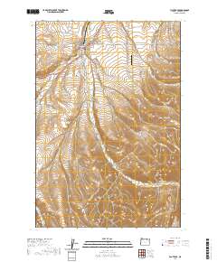
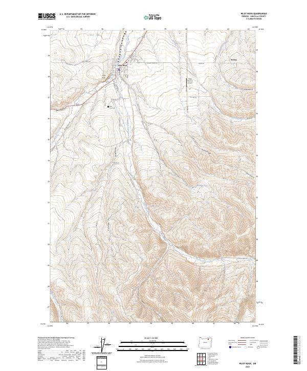 2023 Pilot Rock2023 Print · USGSThe community of Pilot Rock is shown in detail at the 2020s, situated at the junction of the Birch Creek forks. Researchers can trace local landmarks like the Pilot Rock Cem, Rugg Ranches Airport, and the winding course of Stewart Creek.
 - 2024 Map of McKay Reservoir, 2024 Print
 2024 McKay Reservoir2024 Print · USGSUmatilla County's high-desert landscape comes into focus in this contemporary survey of the area surrounding McKay Reservoir. Genealogists and local historians can trace burial sites at McKay Creek Cem and follow the rugged path of George Canyon to the southern landmark of Pilot Rock.
End of results
Showing maps 1-13 of 13
Top cities near Pilot Rock
Frequently asked questions
- What are the different types of historical maps available for Pilot Rock?
- What is the oldest map of Pilot Rock?
- Where can I purchase historical maps of Pilot Rock for my home or office?
- Where can I download high-res historical maps of Pilot Rock?
- Are there historical topographic maps available for Pilot Rock?
- Is there historical aerial imagery available for Pilot Rock?
- Where are historical maps of Pilot Rock sourced from?