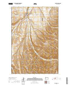
2020 Map of Pilot Rock
USGS Topo · Published 2020About this map
Pilot Rock serves as the primary hub for this portion of Umatilla County, where the convergence of Birch Cr and its western and eastern branches dictates the local topography. The town's grid, including SW Cedar St and Delwood St, transitions quickly into the surrounding agricultural and ranching landscape. Nearby, the Pilot Rock Cem and Rugg Ranches Airport represent significant local landmarks. To the south, the terrain becomes increasingly complex as the drainage systems of Jack Canyon, Spring Hollow, and California Gulch carve through the rising elevation. The prominence of Rocky Ridge and Dry Hollow highlights the interplay between the watercourses and the high ground, while historical routes like Stock Drive Rd and Schoolhouse Rd point to the area's rural development and livestock-based heritage.
Find a feature on this map
42 named features on this map. Tap any name to fly to it.
Don’t see what you’re looking for? This feature index may not catch every label — zoom into the map to look around manually.
Map Details
Editions of this 2020 Pilot Rock Map
This is the sole edition of this map. No revisions or reprints were ever made.
Other maps of this area

1935 · Pendleton
USGS Topo · 1:125,000

1953 · Pendleton
USGS Topo · 1:250,000

1956 · Pendleton
USGS Topo · 1:250,000

1966 · Mc Kay Reservoir
USGS Topo · 1:24,000

1966 · Table Rock
USGS Topo · 1:24,000
1966 · Coombs Canyon
USGS Topo · 1:24,000

1967 · Nye
USGS Topo · 1:24,000

1967 · Granite Meadows
USGS Topo · 1:24,000

1967 · Carney Butte
USGS Topo · 1:24,000

1967 · Pilot Rock
USGS Topo · 1:24,000