1980s Maps of Allegheny County, Pennsylvania
Explore 5 historic maps of Allegheny County from the 1980s. These maps offer a rare glimpse into what life looked like during the 1980s — showing old roads, neighborhoods, homes, and landmarks that have changed or disappeared over time.
Whether you're researching your family's past, planning a metal detecting trip, or studying how Allegheny County's landscape evolved across the 1980s, these high-resolution maps are a powerful tool for exploring the history of this region.
- Focus on a specific era: All maps on this page are from the 1980s, giving you a focused view of this time period.
- See what’s changed: Compare century-old streets, trails, and buildings to today's modern landscape using overlays and satellite layers.
- Research with precision: Use these maps for genealogy, historical research, land use analysis, or educational projects.
- View, download, or print: Maps are fully viewable online in high resolution, and can be downloaded or printed for your own records.
Start exploring Allegheny County's history through authentic maps from the 1980s. This is your window into the past.
Allegheny County, PA maps
(5)- 1983 Map of Indiana
 1983 Indiana1983 Print · USGSWestern Pennsylvania in the early eighties shows a landscape of industrial river towns and expanding university campuses. Genealogists can trace family roots through Lucernemines and Spring Church, or locate ancestors in Oakland Cemetery.
 - 1986 Map of Pittsburgh West
 1986 Pittsburgh West1986 Print · USGSThe Tri-State region's coal and rail corridors are captured in the mid-eighties as industry and aviation expanded. Trace the legacy of extraction at Nelms Mine No 1, locate Short Creek PO, or follow the Chessie System tracks along the Ohio River.3 unique versions available
 - 1986 Map of Pittsburgh East
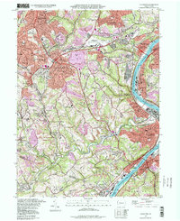
 1986 Pittsburgh East1986 Print · USGSWestern Pennsylvania in the mid-eighties shows a landscape defined by industrial rivers and rising mountain ridges. Trace the dense rail networks of CONRAIL and the Pittsburgh and Lake Erie RR connecting historic centers like Monessen, Jeannette, and Connellsville.3 unique versions available
 - 1986 Map of East Liverpool
 1986 East Liverpool1986 Print · USGSThe tri-state border region in the 1980s reveals a landscape shaped by the Ohio River and a massive rail network. Researchers can trace the industrial footprint of East Liverpool and Midland or locate inland landmarks like Pine Lake and Strip Mines.2 unique versions available
 - 1988 Map of Glassport, 1998 Print
 1988 Glassport1998 Print · USGSThe Monongahela River valley south of Pittsburgh was a dense network of steel-town industry and suburban growth in the late twentieth century. Genealogists and researchers can trace local landmarks like Dam No 3, Mifflin Junction, and Sacred Heart Cem.
End of results
Showing maps 1-5 of 5
Top cities of Allegheny County
- Pittsburgh historical maps
- Penn Hills historical maps
- Bethel Park historical maps
- Ross Township historical maps
- Mount Lebanon historical maps
- McCandless historical maps
See more
Frequently asked questions
- What are the different types of historical maps available for Allegheny County?
- What is the oldest map of Allegheny County?
- Where can I purchase historical maps of Allegheny County for my home or office?
- Where can I download high-res historical maps of Allegheny County?
- Are there historical topographic maps available for Allegheny County?
- Is there historical aerial imagery available for Allegheny County?
- Where are historical maps of Allegheny County sourced from?