1990s Maps of Pittsburgh, Pennsylvania
Explore 6 historic maps of Pittsburgh from the 1990s. These maps offer a rare glimpse into what life looked like during the 1990s — showing old roads, neighborhoods, homes, and landmarks that have changed or disappeared over time.
Whether you're researching your family's past, planning a metal detecting trip, or studying how Pittsburgh's landscape evolved across the 1990s, these high-resolution maps are a powerful tool for exploring the history of this region.
- Focus on a specific era: All maps on this page are from the 1990s, giving you a focused view of this time period.
- See what’s changed: Compare century-old streets, trails, and buildings to today's modern landscape using overlays and satellite layers.
- Research with precision: Use these maps for genealogy, historical research, land use analysis, or educational projects.
- View, download, or print: Maps are fully viewable online in high resolution, and can be downloaded or printed for your own records.
Start exploring Pittsburgh's history through authentic maps from the 1990s. This is your window into the past.
Pittsburgh, PA maps
(6)- 1993 Map of Pittsburgh West, 1994 Print
 1993 Pittsburgh West1994 Print · USGSThe confluence of the Three Rivers defines this western Pennsylvania landscape in the early 1990s. Genealogists and local historians can trace parish cemeteries like Polish Cem, institutional landmarks such as St Pauls Orphanage, and the heavy industrial corridor along the Ohio River.2 unique versions available
 - 1993 Map of Pittsburgh East, 1994 Print
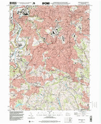
 1993 Pittsburgh East1994 Print · USGSThe industrial and academic heart of western Pennsylvania is captured here in the early nineties, showing Pittsburgh as its neighborhoods and riverfronts continued to evolve. Researchers can locate family sites near Allegheny Cemetery, trace the campus footprints of Carnegie Mellon University, or find local landmarks like the Civic Arena.2 unique versions available
 - 1993 Map of Bridgeville, 1999 Print
 1993 Bridgeville1999 Print · USGSSouth of Pittsburgh in the early nineties, these hills show a landscape of maturing suburbs and industrial remnants. Trace local history at St Francis Academy, Anne Siding, and the sprawling Queen of Heaven Cemetery.
 - 1993 Map of Emsworth, 1999 Print
 1993 Emsworth1999 Print · USGSThe northern Pittsburgh suburbs and the Ohio River corridor are shown during a decade of rapid growth in the early nineties. Genealogists can trace family sites at Dixmont State Hospital, North Side Cemetery, and Tree of Life Memorial Park.
 - 1997 Map of Pittsburgh West, 1998 Print
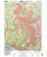
 1997 Pittsburgh West1998 Print · USGSThe confluence of the three rivers and the western suburbs of Allegheny County are captured here in the late nineties. Researchers can trace historic parochial sites like St Pauls Orphanage and institutional landmarks such as the State Penitentiary.2 unique versions available
 - 1997 Map of Pittsburgh East, 2000 Print
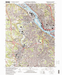
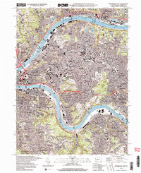 1997 Pittsburgh East2000 Print · USGSAllegheny County at the close of the twentieth century shows a landscape defined by industrial rivers and established urban neighborhoods. Researchers can trace the legacy of local parishes and families through Allegheny Cemetery, St Nicholas Cem, and dozens of landmarks from Millvale to Wilkinsburg.2 unique versions available
End of results
Showing maps 1-6 of 6
Top cities near Pittsburgh
- Penn Hills historical maps
- Bethel Park historical maps
- Ross Township historical maps
- Mount Lebanon historical maps
- McCandless historical maps
- Monroeville historical maps
See more
Top neighborhoods of Pittsburgh
- East Liberty historical maps
- Upper Terrace historical maps
- Lower Terrace historical maps
- East Hills historical maps
- Overbrook historical maps
- Summer Hill historical maps
See more
Frequently asked questions
- What are the different types of historical maps available for Pittsburgh?
- What is the oldest map of Pittsburgh?
- Where can I purchase historical maps of Pittsburgh for my home or office?
- Where can I download high-res historical maps of Pittsburgh?
- Are there historical topographic maps available for Pittsburgh?
- Is there historical aerial imagery available for Pittsburgh?
- Where are historical maps of Pittsburgh sourced from?