1950s Maps of Pittsburgh, Pennsylvania
Explore 15 historic maps of Pittsburgh from the 1950s. These maps offer a rare glimpse into what life looked like during the 1950s — showing old roads, neighborhoods, homes, and landmarks that have changed or disappeared over time.
Whether you're researching your family's past, planning a metal detecting trip, or studying how Pittsburgh's landscape evolved across the 1950s, these high-resolution maps are a powerful tool for exploring the history of this region.
- Focus on a specific era: All maps on this page are from the 1950s, giving you a focused view of this time period.
- See what’s changed: Compare century-old streets, trails, and buildings to today's modern landscape using overlays and satellite layers.
- Research with precision: Use these maps for genealogy, historical research, land use analysis, or educational projects.
- View, download, or print: Maps are fully viewable online in high resolution, and can be downloaded or printed for your own records.
Start exploring Pittsburgh's history through authentic maps from the 1950s. This is your window into the past.
Pittsburgh, PA maps
(15)- 1951 Map of Pittsburgh West
 1951 Pittsburgh West1951 Print · USGSThe industrial heart of Allegheny County is captured at mid-century as neighborhoods expanded across the hills west of the rivers. Researchers can trace the rail lines through McKees Rocks, find ancestors at Highwood Cemetery, or locate old landmarks like the Allegheny Observatory.3 unique versions available
 - 1951 Map of Pittsburg East
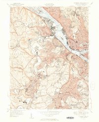
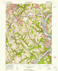
 1951 Pittsburg East1951 Print · USGSThe eastern reaches of Pittsburgh and its river valleys are shown here in the early postwar era. Researchers can trace the footprints of iconic landmarks like Forbes Field and the University of Pittsburgh or locate family plots in Allegheny Cemetery.3 unique versions available
 - 1951 Map of Canton
 1951 Canton1951 Print · USGSThe industrial heartland of Ohio and Pennsylvania reached its mid-century peak during this era of heavy rail and river transit. Genealogists and historians can trace the development of steel towns like Aliquippa and Weirton alongside the Ohio River and major lines of the Pennsylvania RR.
 - 1953 Map of Pittsburgh
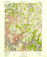
 1953 Pittsburgh1953 Print · USGSWestern Pennsylvania's industrial landscape at the start of the fifties shows the steel and rail corridors between Pittsburgh and Altoona. Trace family roots in river towns like Tarentum or follow the Pennsylvania Turnpike across Laurel Hill.
 - 1953 Map of Canton
 1953 Canton1953 Print · USGSThe industrial heartland of Ohio and Pennsylvania is captured at its mid-century peak in this detailed regional survey. Genealogists and historians can trace the vast rail networks of the Pennsylvania RR and find local landmarks like Nimisila Reservoir and Tappan Reservoir.
 - 1953 Map of Braddock, 1955 Print
 1953 Braddock1955 Print · USGSAllegheny County's industrial heartland thrives in the mid-fifties as dense valley towns like Braddock and Wilmerding expand into the surrounding hills. Genealogists and historians can trace neighborhood growth through dozens of landmarks, from Kennywood Amusement Park to Beulah Ch and the Pennsylvania RR rail lines.
 - 1953 Map of Bridgeville, 1955 Print
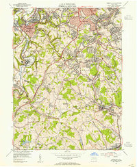 1953 Bridgeville1955 Print · USGSAllegheny and Washington Counties were transitioning from a mining economy to a suburban landscape in the early fifties. Genealogists and historians can trace family roots through the Melrose Cem, identify old industrial sites like Hickman Shafts, or locate the Mayer Airport.
 - 1953 Map of Glassport, 1955 Print
 1953 Glassport1955 Print · USGSThe industrial Monongahela Valley and its burgeoning suburbs are detailed here during the mid-fifties. Trace the rail-and-river network through Glassport or find family landmarks like Cochrans Mill, St Peters Ch, and Memorial Cemetery.
 - 1953 Map of Emsworth, 1955 Print
 1953 Emsworth1955 Print · USGSNorth of Pittsburgh in the early fifties, the riverfront communities and hilly suburbs show a mix of industry and institutional growth. Researchers can trace the grounds of the Dixmont State Hospital and schools like Mt Nazareth Academy or the Sisters of the Holy Ghost Sch.
 - 1954 Map of Pittsburgh
 1954 Pittsburgh1954 Print · USGSWestern Pennsylvania in the early fifties remains a powerhouse of heavy industry and vital transit corridors. Genealogists and historians can trace the rail-and-river network connecting Pittsburgh, Johnstown, and Altoona via the Pennsylvania RR and the Lincoln Highway.2 unique versions available
 - 1956 Map of Pittsburgh East, 1959 Print
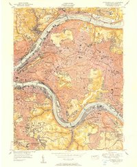
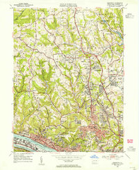
 1956 Pittsburgh East1959 Print · USGSMid-century Pittsburgh and its eastern boroughs appear here during a peak era of industrial and academic expansion. Trace the rail-integrated neighborhoods from Lawrenceville to Wilkinsburg, including the historic Allegheny Cemetery and Frick Park.
 - 1956 Map of Pittsburgh West, 1959 Print
 1956 Pittsburgh West1959 Print · USGSWestern Pittsburgh and its industrial riverfronts are captured here during the mid-fifties era of bridge building and suburban expansion. Genealogists and researchers can locate neighborhood landmarks like Chartiers Cem, the Western State Penitentiary, and the Allegheny Observatory.
 - 1957 Map of Canton, 1971 Print
 1957 Canton1971 Print · USGSThe industrial heartland of eastern Ohio and western Pennsylvania comes alive in this mid-century survey of the Ohio River Valley. Trace the heritage of rail and river commerce through Pittsburgh, the massive steel towns along the Ohio River, and major junctions on the Pennsylvania RR.3 unique versions available
 - 1958 Map of Pittsburgh
 1958 Pittsburgh1958 Print · USGSWestern Pennsylvania in the late fifties shows an industrial heartland defined by the confluence of the Allegheny River and Monongahela River. Researchers can trace the sprawling rail networks of the Pennsylvania RR and find established towns like Butler, Latrobe, and Windber.5 unique versions available
 - 1959 Map of Pittsburgh
 1959 Pittsburgh1959 Print · USGSWestern Pennsylvania in the late fifties is captured here at the height of its industrial era. Genealogists and historians can trace the riverfront growth of Pittsburgh, the rail works at Altoona, and the mountain gaps of Laurel Hill.
End of results
Showing maps 1-15 of 15
Top cities near Pittsburgh
- Penn Hills historical maps
- Bethel Park historical maps
- Ross Township historical maps
- Mount Lebanon historical maps
- McCandless historical maps
- Monroeville historical maps
See more
Top neighborhoods of Pittsburgh
- East Liberty historical maps
- Lower Terrace historical maps
- Upper Terrace historical maps
- Marshall Shadeland historical maps
- Arlington Heights historical maps
- West End historical maps
See more
Frequently asked questions
- What are the different types of historical maps available for Pittsburgh?
- What is the oldest map of Pittsburgh?
- Where can I purchase historical maps of Pittsburgh for my home or office?
- Where can I download high-res historical maps of Pittsburgh?
- Are there historical topographic maps available for Pittsburgh?
- Is there historical aerial imagery available for Pittsburgh?
- Where are historical maps of Pittsburgh sourced from?