1990s Maps of South Fayette Township, Pennsylvania
Explore 2 historic maps of South Fayette Township from the 1990s. These maps offer a rare glimpse into what life looked like during the 1990s — showing old roads, neighborhoods, homes, and landmarks that have changed or disappeared over time.
Whether you're researching your family's past, planning a metal detecting trip, or studying how South Fayette Township's landscape evolved across the 1990s, these high-resolution maps are a powerful tool for exploring the history of this region.
- Focus on a specific era: All maps on this page are from the 1990s, giving you a focused view of this time period.
- See what’s changed: Compare century-old streets, trails, and buildings to today's modern landscape using overlays and satellite layers.
- Research with precision: Use these maps for genealogy, historical research, land use analysis, or educational projects.
- View, download, or print: Maps are fully viewable online in high resolution, and can be downloaded or printed for your own records.
Start exploring South Fayette Township's history through authentic maps from the 1990s. This is your window into the past.
South Fayette Township, PA maps
(2)- 1993 Map of Bridgeville, 1999 Print
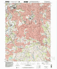 1993 Bridgeville1999 Print · USGSSouth of Pittsburgh in the early nineties, these hills show a landscape of maturing suburbs and industrial remnants. Trace local history at St Francis Academy, Anne Siding, and the sprawling Queen of Heaven Cemetery.
 - 1993 Map of Oakdale, 1999 Print
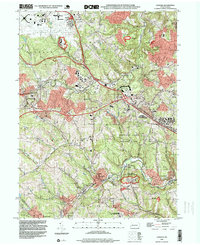 1993 Oakdale1999 Print · USGSAllegheny County in the early 1990s shows a landscape defined by industrial legacy and the growth of the Greater Pittsburgh International Airport. Genealogists and historians can trace local family roots through sites like Resurrection Cemetery, Cliff Mine, and the Montour RR corridor.
End of results
Showing maps 1-2 of 2
Top cities near South Fayette Township
- Pittsburgh historical maps
- Bethel Park historical maps
- Ross Township historical maps
- Mount Lebanon historical maps
- McCandless historical maps
- Moon Township historical maps
See more
Top neighborhoods of South Fayette Township
- Morgan historical maps
- Morgan Hill historical maps
- Sygan historical maps
- Sygan Hill historical maps
- Cuddy Hill historical maps
- Federal historical maps
See more
Frequently asked questions
- What are the different types of historical maps available for South Fayette Township?
- What is the oldest map of South Fayette Township?
- Where can I purchase historical maps of South Fayette Township for my home or office?
- Where can I download high-res historical maps of South Fayette Township?
- Are there historical topographic maps available for South Fayette Township?
- Is there historical aerial imagery available for South Fayette Township?
- Where are historical maps of South Fayette Township sourced from?