Old Maps of South Bethlehem, Armstrong County for Genealogy
Trace your family roots with 17 historic maps of South Bethlehem. These high-res maps reveal old neighborhoods, homesites, landmarks, and streets — helping you uncover where your ancestors lived and how the area evolved over time.
- Explore historic neighborhoods: Identify where your relatives may have lived in the 1800s or 1900s.
- Compare maps over time: Trace the changes in streets, buildings, and landmarks for multi-generational research.
- Perfect for genealogy & ancestry research: Used by family historians and researchers to map out lineage and migration.
These maps are an incredible resource for exploring your personal connection to South Bethlehem's past.
South Bethlehem, Armstrong County maps
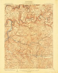
(17)- 1901 Map of Rural Valley, 1957 Print
 1901 Rural Valley1957 Print · USGSCovers South Bethlehem, including Mahoning, Rural Valley, and other nearby areas2 unique versions available
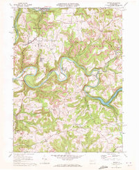
 - 1903 Map of Rural Valley
 1903 Rural Valley1903 Print · USGSCovers South Bethlehem, including Mahoning, Rural Valley, and other nearby areas6 unique versions available
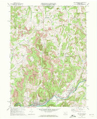
 - 1906 Map of Clarion
 1906 Clarion1906 Print · USGSCovers South Bethlehem, including Clarion, Limestone Township, and other nearby areas2 unique versions available
 - 1907 Map of Clarion
 1907 Clarion1907 Print · USGSCovers South Bethlehem, including Clarion, Limestone Township, and other nearby areas5 unique versions available
 - 1953 Map of Pittsburgh
 1953 Pittsburgh1953 Print · USGSCovers South Bethlehem, including Pittsburgh, Penn Hills, and other nearby areas
 - 1954 Map of Pittsburgh
 1954 Pittsburgh1954 Print · USGSCovers South Bethlehem, including Pittsburgh, Penn Hills, and other nearby areas2 unique versions available
 - 1957 Map of Warren, 1964 Print
 1957 Warren1964 Print · USGSCovers South Bethlehem, including Saint Marys, Sandy Township, and other nearby areas4 unique versions available
 - 1958 Map of Pittsburgh
 1958 Pittsburgh1958 Print · USGSCovers South Bethlehem, including Pittsburgh, Penn Hills, and other nearby areas5 unique versions available
 - 1958 Map of Warren
 1958 Warren1958 Print · USGSCovers South Bethlehem, including Saint Marys, Sandy Township, and other nearby areas
 - 1959 Map of Warren
 1959 Warren1959 Print · USGSCovers South Bethlehem, including Saint Marys, Sandy Township, and other nearby areas2 unique versions available
 - 1959 Map of Pittsburgh
 1959 Pittsburgh1959 Print · USGSCovers South Bethlehem, including Pittsburgh, Penn Hills, and other nearby areas
 - 1964 Map of Pittsburgh
 1964 Pittsburgh1964 Print · USGSCovers South Bethlehem, including Pittsburgh, Penn Hills, and other nearby areas
 - 1969 Map of Distant, 1972 Print
 1969 Distant1972 Print · USGSCovers South Bethlehem, including McCrea Furnace, Wayne Township, and other nearby areas3 unique versions available
 - 1969 Map of New Bethlehem, 1972 Print
 1969 New Bethlehem1972 Print · USGSCovers South Bethlehem, including Limestone Township, New Bethlehem, and other nearby areas2 unique versions available
 - 1971 Map of Warren
 1971 Warren1971 Print · USGSCovers South Bethlehem, including Saint Marys, Sandy Township, and other nearby areas
 - 1983 Map of Indiana
 1983 Indiana1983 Print · USGSCovers South Bethlehem, including Penn Hills, Ross Township, and other nearby areas
 - 1983 Map of Oil City, 1984 Print
 1983 Oil City1984 Print · USGSCovers South Bethlehem, including Oil City, Cranberry Township, and other nearby areas
End of results
Showing maps 1-17 of 17
Frequently asked questions
- What are the different types of historical maps available for South Bethlehem?
- What is the oldest map of South Bethlehem?
- Where can I purchase historical maps of South Bethlehem for my home or office?
- Where can I download high-res historical maps of South Bethlehem?
- Are there historical topographic maps available for South Bethlehem?
- Is there historical aerial imagery available for South Bethlehem?
- Where are historical maps of South Bethlehem sourced from?