1900s (20th Century) Maps of Georgetown, Beaver County
Explore 13 historic maps of Georgetown from the 1900s (20th Century). These maps offer a rare glimpse into what life looked like during the 1900s — showing old roads, neighborhoods, homes, and landmarks that have changed or disappeared over time.
Whether you're researching your family's past, planning a metal detecting trip, or studying how Georgetown's landscape evolved across the 1900s, these high-resolution maps are a powerful tool for exploring the history of this region.
- Focus on a specific era: All maps on this page are from the 1900s, giving you a focused view of this time period.
- See what’s changed: Compare century-old streets, trails, and buildings to today's modern landscape using overlays and satellite layers.
- Research with precision: Use these maps for genealogy, historical research, land use analysis, or educational projects.
- View, download, or print: Maps are fully viewable online in high resolution, and can be downloaded or printed for your own records.
Start exploring Georgetown's history through authentic maps from the 1900s. This is your window into the past.
Georgetown, Beaver County maps
(13)- 1901 Map of Beaver, 1958 Print
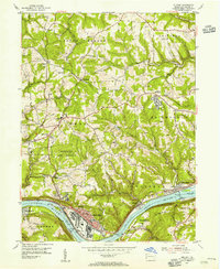
 1901 Beaver1958 Print · USGSThe industrial river valleys of Beaver County at the dawn of the twentieth century are captured here in meticulous detail. Researchers can trace the development of Beaver Falls and Rochester or locate riverside landmarks like Baker's Landing and Dam No. 6.
 - 1904 Map of Wellsville
 1904 Wellsville1904 Print · USGSThe tri-state border region along the OHIO RIVER is captured here during the peak of its rail-and-river expansion. Genealogists can trace family footprints in Wellsville or find early rural landmarks like Grimm's Bridge and Cannon's Mill.3 unique versions available
 - 1904 Map of Beaver
 1904 Beaver1904 Print · USGSBeaver County at the opening of the twentieth century shows a landscape defined by the bustling industrial corridors of the Ohio River. Genealogists can trace family roots through riverfront settlements like Monaca, Shippingport, and Freedom, or locate early transport hubs such as Cooks Ferry.6 unique versions available
 - 1937 Map of Wellsville, 1960 Print
 1937 Wellsville1960 Print · USGSThe Ohio River valley thrives as a Tri-State industrial hub in the years before the Second World War. Researchers can trace the riverfront rail lines of the Pennsylvania RR and locate vanished local landmarks like Pughtown PO and Nessly Chapel.
 - 1944 Map of Wellsville
 1944 Wellsville1944 Print · USGSThe industrial heart of the Ohio River valley comes to life in the 1940s, showing the bustling riverfronts of Wellsville and East Liverpool. Researchers can trace the Pennsylvania RR lines and find local landmarks like Grimms Bridge and Pughtown PO.2 unique versions available
 - 1951 Map of Canton
 1951 Canton1951 Print · USGSThe industrial heartland of Ohio and Pennsylvania reached its mid-century peak during this era of heavy rail and river transit. Genealogists and historians can trace the development of steel towns like Aliquippa and Weirton alongside the Ohio River and major lines of the Pennsylvania RR.
 - 1953 Map of Canton
 1953 Canton1953 Print · USGSThe industrial heartland of Ohio and Pennsylvania is captured at its mid-century peak in this detailed regional survey. Genealogists and historians can trace the vast rail networks of the Pennsylvania RR and find local landmarks like Nimisila Reservoir and Tappan Reservoir.
 - 1954 Map of Midland, 1955 Print
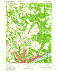
 1954 Midland1955 Print · USGSThe Ohio River industrial corridor in the mid-1950s comes to life in this survey of Beaver County. Genealogists can trace family names at Salem Cemetery and Georgetown Cemetery, or locate community landmarks like Lincoln High School and Bethlehem Church.5 unique versions available
 - 1957 Map of Canton, 1971 Print
 1957 Canton1971 Print · USGSThe industrial heartland of eastern Ohio and western Pennsylvania comes alive in this mid-century survey of the Ohio River Valley. Trace the heritage of rail and river commerce through Pittsburgh, the massive steel towns along the Ohio River, and major junctions on the Pennsylvania RR.3 unique versions available
 - 1960 Map of East Liverpool North, 1962 Print
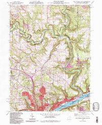
 1960 East Liverpool North1962 Print · USGSThe industrial riverfront of the Ohio Valley meets the historic tri-state border lands in the early 1960s. Genealogists and historians can trace the geodetic history of the Geographers Line or locate family sites at Riverview Cemetery and Spring Grove.6 unique versions available
 - 1962 Map of Canton
 1962 Canton1962 Print · USGSThe industrial heartland of Eastern Ohio and Western Pennsylvania thrives in the early sixties as steel mills and rail lines dominate the river valleys. Genealogists and historians can trace local landmarks like McKinley National Memorial, Malone College, and industrial sites such as Republic Steel Corp.2 unique versions available
 - 1986 Map of East Liverpool
 1986 East Liverpool1986 Print · USGSThe tri-state border region in the 1980s reveals a landscape shaped by the Ohio River and a massive rail network. Researchers can trace the industrial footprint of East Liverpool and Midland or locate inland landmarks like Pine Lake and Strip Mines.2 unique versions available
 - 1994 Map of East Liverpool North, 1998 Print
 1994 East Liverpool North1998 Print · USGSThe tri-state border region of Ohio, Pennsylvania, and West Virginia is captured here in the late twentieth century as the industrial legacy of the Ohio River meets the protected valley of Little Beaver Creek. Researchers can locate family sites at Riverview Cemetery or trace old routes through Calcutta and Sprucevale.
End of results
Showing maps 1-13 of 13
Frequently asked questions
- What are the different types of historical maps available for Georgetown?
- What is the oldest map of Georgetown?
- Where can I purchase historical maps of Georgetown for my home or office?
- Where can I download high-res historical maps of Georgetown?
- Are there historical topographic maps available for Georgetown?
- Is there historical aerial imagery available for Georgetown?
- Where are historical maps of Georgetown sourced from?