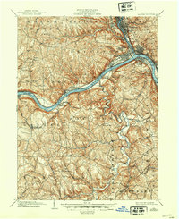
1901 Map of Beaver
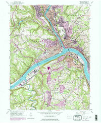
USGS Topo · Published 1958About this map
Industrial hubs and riverfront landings define this turn-of-the-century landscape at the confluence of the Beaver River and the Ohio River. The river-level towns of Rochester, Beaver, and Monaca appear as dense grids, while smaller riverside settlements like Vanport, Bellowsville, and Freedom highlight the early 20th-century dependence on waterway transport and the Pittsburg and Cleveland rail lines. Navigation on the Ohio is marked by early infrastructure, including Dam No. 5 and Dam No. 6, which facilitated the transport of goods before modern lock systems were fully established.
Find a feature on this map
96 named features on this map. Tap any name to fly to it.
Don’t see what you’re looking for? This feature index may not catch every label — zoom into the map to look around manually.
Map Details
Editions of this 1901 Beaver Map
This is the sole edition of this map. No revisions or reprints were ever made.
Historical Maps of Moon Township Through Time
4 maps found