1902 Map of New Castle
USGS Topo · Published 1956About this map
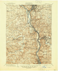
The industrial and rail nexus of Lawrence County emerges at the confluence of the Shenango River and the Mahoning River, where New Castle serves as the dominant urban hub. This survey illustrates a landscape deeply shaped by heavy transport, with the Pittsburgh and Lake Erie RR and the Pittsburgh Ft Wayne and Chicago RR threading through river valleys to connect regional manufacturing centers. To the south, Ellwood City stands as a secondary industrial focus, flanked by the steep banks of Slippery Rock Creek and the Connoquenessing Creek. The map documents the intricate network of junctions and small company towns, such as West Pittsburg and Newport, that supported the early 20th-century steel and coal economies. Smaller agricultural and transit hamlets like Enon Valley and New Galilee occupy the western uplands, providing a sharp contrast to the dense rail yards of Mahoningtown.
Find a feature on this map
86 named features on this map. Tap any name to fly to it.
Don’t see what you’re looking for? This feature index may not catch every label — zoom into the map to look around manually.
Map Details
Editions of this 1902 New Castle Map
This is the sole edition of this map. No revisions or reprints were ever made.