1900-1909 Maps of Bedford, Pennsylvania
Explore 3 historic maps of Bedford from 1900-1909. These maps offer a rare glimpse into what life looked like during the 1900s — showing old roads, neighborhoods, homes, and landmarks that have changed or disappeared over time.
Whether you're researching your family's past, planning a metal detecting trip, or studying how Bedford's landscape evolved across the 1900s, these high-resolution maps are a powerful tool for exploring the history of this region.
- Focus on a specific era: All maps on this page are from the 1900s, giving you a focused view of this time period.
- See what’s changed: Compare century-old streets, trails, and buildings to today's modern landscape using overlays and satellite layers.
- Research with precision: Use these maps for genealogy, historical research, land use analysis, or educational projects.
- View, download, or print: Maps are fully viewable online in high resolution, and can be downloaded or printed for your own records.
Start exploring Bedford's history through authentic maps from the 1900s. This is your window into the past.
Bedford, PA maps
(3)- 1900 Map of Everett, 1959 Print
 1900 Everett1959 Print · USGSBedford County at the turn of the century shows a landscape of deep limestone valleys and industrial river towns. Genealogists and historians can trace family-named sites and rail stops from Everett to New Enterprise and the river depot at Cypher Sta.
 - 1902 Map of Everett
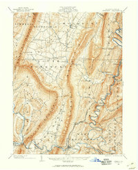
 1902 Everett1902 Print · USGSBedford County at the start of the twentieth century shows a landscape of deep ridge-and-valley industry and isolated mountain coves. Genealogists and historians can trace old homesteads and rail stops near Everett, New Enterprise, and the Valley Mill along Snake Spring Run.7 unique versions available
 - 1908 Map of Bedford, 1958 Print
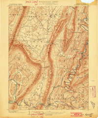
 1908 Bedford1958 Print · USGSBedford County at the turn of the century reveals a landscape of ridge-top schools and valley mill towns connected by early rail. Genealogists can trace family roots through numerous sites like Ryan Mill, Eight Square School, and Ogleton Felix PO.
End of results
Showing maps 1-3 of 3
Top cities near Bedford
- Napier Township historical maps
- Everett historical maps
- Hyndman historical maps
- Pavia Township historical maps
- Schellsburg historical maps
- Manns Choice historical maps
See more
Frequently asked questions
- What are the different types of historical maps available for Bedford?
- What is the oldest map of Bedford?
- Where can I purchase historical maps of Bedford for my home or office?
- Where can I download high-res historical maps of Bedford?
- Are there historical topographic maps available for Bedford?
- Is there historical aerial imagery available for Bedford?
- Where are historical maps of Bedford sourced from?