1900 Map of Everett
USGS Topo · Published 1959About this map
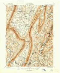
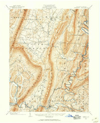
Everett serves as the focal point of this 1900 survey, situated along the winding loops of the Raystown Branch Juniata River. The map captures the industrial and agricultural heart of Bedford County at the turn of the century, where the H. and B. M. R. R. follows the river corridor to serve coal-rich areas like Riddlesburg and Hopewell. The landscape is sharply defined by the parallel ridges of Tussey Mountain and Dunning Mountain, which isolate fertile valleys like Dutch Corner and Snake Spring Valley. Small hamlets and crossroads such as New Enterprise, Lafayetteville, and Waterside are connected by a network of early roads, while sites like Valley Mill indicate the local water-powered economy. The presence of Cypher Sta. and Mt. Dallas highlights the importance of rail logistics in moving resources from the Broadtop region to the wider Pennsylvania market.
Find a feature on this map
65 named features on this map. Tap any name to fly to it.
Don’t see what you’re looking for? This feature index may not catch every label — zoom into the map to look around manually.
Map Details
Editions of this 1900 Everett Map
This is the sole edition of this map. No revisions or reprints were ever made.