1970s Maps of Juniata Township, Pennsylvania
Explore 5 historic maps of Juniata Township from the 1970s. These maps offer a rare glimpse into what life looked like during the 1970s — showing old roads, neighborhoods, homes, and landmarks that have changed or disappeared over time.
Whether you're researching your family's past, planning a metal detecting trip, or studying how Juniata Township's landscape evolved across the 1970s, these high-resolution maps are a powerful tool for exploring the history of this region.
- Focus on a specific era: All maps on this page are from the 1970s, giving you a focused view of this time period.
- See what’s changed: Compare century-old streets, trails, and buildings to today's modern landscape using overlays and satellite layers.
- Research with precision: Use these maps for genealogy, historical research, land use analysis, or educational projects.
- View, download, or print: Maps are fully viewable online in high resolution, and can be downloaded or printed for your own records.
Start exploring Juniata Township's history through authentic maps from the 1970s. This is your window into the past.
Juniata Township, PA maps
(5)- 1971 Map of Schellsburg, 1972 Print
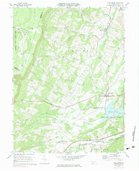
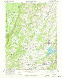 1971 Schellsburg1972 Print · USGSBedford County at the start of the seventies reveals a landscape of protected game lands and emerging state recreation areas. Genealogists and hikers can trace old homesteads near New Paris, remote churches like Pleasant View Ch, and the shoreline of Shawnee Lake.3 unique versions available
 - 1971 Map of Central City, 1972 Print
 1971 Central City1972 Print · USGSSomerset County coal towns and lakeside developments are captured here in the early seventies. Genealogists and industrial historians can trace the Penn Central rail lines connecting Central City and Cairnbrook to local strip mines and the Township High Sch.2 unique versions available
 - 1977 Map of New Baltimore, 1979 Print
 1977 New Baltimore1979 Print · USGSThe Somerset County countryside comes into focus in the late seventies, showing the intricate patchwork of farms and timber along the Raystown Branch Juniata River. Trace the rural layout of New Baltimore, Mt Zion, and the high terrain of Dividing Ridge.
 - 1977 Map of Central City, 1979 Print
 1977 Central City1979 Print · USGSSomerset County's coal towns and developing lakes are seen in this late-seventies aerial survey. Trace industrial land use and neighborhood growth near Central City or explore the shorelines of Indian Lake and Lake Stonycreek.
 - 1977 Map of Schellsburg, 1979 Print
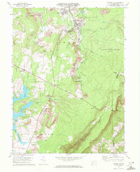
 1977 Schellsburg1979 Print · USGSBedford County during the late seventies shows a rural landscape defined by the winding Raystown Branch Juniata River and the recreation area at Shawnee Lake. Genealogists can locate family roots in New Paris, Helixville, or Schellsburg, while tracing local landmarks like the New Paris Central Sch and two historic Covered Bridge crossings.
End of results
Showing maps 1-5 of 5
Top cities near Juniata Township
- Bedford historical maps
- Napier Township historical maps
- Central City historical maps
- Fairhope Township historical maps
- Hyndman historical maps
- Hooversville historical maps
See more
Top neighborhoods of Juniata Township
- Kegg historical maps
- New Buena Vista historical maps
- West End historical maps
- Grand View historical maps
Frequently asked questions
- What are the different types of historical maps available for Juniata Township?
- What is the oldest map of Juniata Township?
- Where can I purchase historical maps of Juniata Township for my home or office?
- Where can I download high-res historical maps of Juniata Township?
- Are there historical topographic maps available for Juniata Township?
- Is there historical aerial imagery available for Juniata Township?
- Where are historical maps of Juniata Township sourced from?