1950s Maps of Centre Township, Pennsylvania
Explore 9 historic maps of Centre Township from the 1950s. These maps offer a rare glimpse into what life looked like during the 1950s — showing old roads, neighborhoods, homes, and landmarks that have changed or disappeared over time.
Whether you're researching your family's past, planning a metal detecting trip, or studying how Centre Township's landscape evolved across the 1950s, these high-resolution maps are a powerful tool for exploring the history of this region.
- Focus on a specific era: All maps on this page are from the 1950s, giving you a focused view of this time period.
- See what’s changed: Compare century-old streets, trails, and buildings to today's modern landscape using overlays and satellite layers.
- Research with precision: Use these maps for genealogy, historical research, land use analysis, or educational projects.
- View, download, or print: Maps are fully viewable online in high resolution, and can be downloaded or printed for your own records.
Start exploring Centre Township's history through authentic maps from the 1950s. This is your window into the past.
Centre Township, PA maps
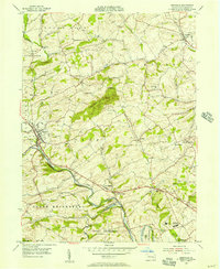
(9)- 1950 Map of Harrisburg, 1952 Print
 1950 Harrisburg1952 Print · USGSMid-century Central Pennsylvania comes alive through its dense rail networks and river valley settlements during the post-war industrial era. Genealogists and historians can trace family roots through hubs like Harrisburg, locate Carlisle Barracks, or follow the Pennsylvania RR through the Lebanon Valley.
 - 1953 Map of Wernersville
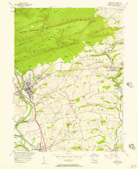
 1953 Wernersville1953 Print · USGSBerks and Lebanon counties are shown in detail during the early 1950s, highlighting a landscape of institutional growth and deep-rooted rural settlements. Genealogists can locate family landmarks like the Bethany Orphans Home, Kricks Mill, and the Blue Meeting House.
 - 1955 Map of Bernville, 1956 Print
 1955 Bernville1956 Print · USGSBerks County farmland and rural settlements are documented here in the mid-fifties, centered on the historic Bernville. Genealogists can trace family landmarks like Bellemans Ch, Stump Cem, and the old Union Canal.5 unique versions available
 - 1956 Map of Newark
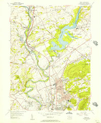
 1956 Newark1956 Print · USGSThe industrial heart of the Mid-Atlantic is captured here at the dawn of the highway era, tracing the dense corridors between Newark and Philadelphia. Genealogists and local historians can map the rail networks of the Reading RR or locate mid-century military life at Fort Dix Military Reservation.2 unique versions available
 - 1956 Map of Hamburg, 1957 Print
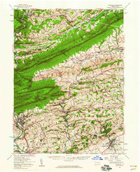
 1956 Hamburg1957 Print · USGSBerks County is captured here in the mid-1950s, where the industrial valley of the Schuylkill River meets the ridge of Blue Mountain. Genealogists and researchers can find Five Locks, the Hamburg Tuberculosis Sanatorium, and local schools like Heinly Sch.10 unique versions available
 - 1956 Map of Temple, 1957 Print
 1956 Temple1957 Print · USGSBerks County's industrial and rural landscape is shown in detail during the mid-1950s as the Schuylkill River valley supported a dense network of rail and river infrastructure. Genealogists and local historians can trace family-named sites and vanished landmarks from Shoemakersville to the General Carl A Spaatz Field.5 unique versions available
 - 1956 Map of Hamburg, 1960 Print
 1956 Hamburg1960 Print · USGSPennsylvania's ridge-and-valley country comes to life in the mid-fifties, from the Schuylkill River to the Lehigh border. Genealogists and hikers can trace the Appalachian Trail over Blue Mountain or locate family roots near New Bethel Ch and Crystal Cave.2 unique versions available
 - 1957 Map of Harrisburg
 1957 Harrisburg1957 Print · USGSMid-century Central Pennsylvania comes into focus as a bustling network of rail, river, and mountain ridges. Genealogists and historians can trace the development of the State Capitol and surrounding hubs like Middletown, Columbia, and Pottsville.7 unique versions available
 - 1957 Map of Newark
 1957 Newark1957 Print · USGSThe industrial and military heart of the Mid-Atlantic is mapped during its post-war suburban boom. Genealogists and historians can trace the intricate rail corridors of the Reading Railroad and locate key landmarks from Princeton University to Fort Hancock.
End of results
Showing maps 1-9 of 9
Top cities near Centre Township
- Reading historical maps
- Muhlenberg Park historical maps
- Pottsville historical maps
- Wyomissing historical maps
- Maxatawny Township historical maps
- Clay Township historical maps
See more
Top neighborhoods of Centre Township
Frequently asked questions
- What are the different types of historical maps available for Centre Township?
- What is the oldest map of Centre Township?
- Where can I purchase historical maps of Centre Township for my home or office?
- Where can I download high-res historical maps of Centre Township?
- Are there historical topographic maps available for Centre Township?
- Is there historical aerial imagery available for Centre Township?
- Where are historical maps of Centre Township sourced from?