1940s Maps of Union Township, Pennsylvania
Explore 8 historic maps of Union Township from the 1940s. These maps offer a rare glimpse into what life looked like during the 1940s — showing old roads, neighborhoods, homes, and landmarks that have changed or disappeared over time.
Whether you're researching your family's past, planning a metal detecting trip, or studying how Union Township's landscape evolved across the 1940s, these high-resolution maps are a powerful tool for exploring the history of this region.
- Focus on a specific era: All maps on this page are from the 1940s, giving you a focused view of this time period.
- See what’s changed: Compare century-old streets, trails, and buildings to today's modern landscape using overlays and satellite layers.
- Research with precision: Use these maps for genealogy, historical research, land use analysis, or educational projects.
- View, download, or print: Maps are fully viewable online in high resolution, and can be downloaded or printed for your own records.
Start exploring Union Township's history through authentic maps from the 1940s. This is your window into the past.
Union Township, PA maps
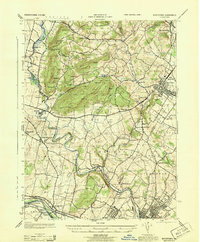
(8)- 1941 Map of Honeybrook
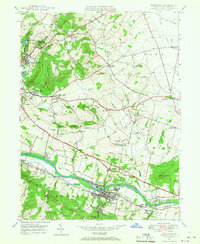
 1941 Honeybrook1941 Print · USGSSoutheastern Pennsylvania at the onset of the Second World War shows a landscape of established farm communities and the newly cut path of the Pennsylvania Turnpike. Researchers can locate numerous local landmarks such as Silver Hill School, Stone Church, and the rail stops along the Reading Lines.
 - 1943 Map of Boyertown
 1943 Boyertown1943 Print · USGSBerks and Montgomery counties are shown at a wartime peak of rail and river industry, centered on the growing boroughs of Boyertown and Pottstown. Genealogists and historians can trace the mid-century layout of Pine Forge, the historic Schuylkill Canal, and local landmarks like Half Way House.
 - 1943 Map of Phoenixville
 1943 Phoenixville1943 Print · USGSSoutheastern Pennsylvania during the early war years shows a landscape defined by the winding Schuylkill River and heavy rail traffic. Genealogists and historians can trace the early Pennsylvania Turnpike and explore historic locales like Fricks Lock and Nantmeal Village.
 - 1944 Map of Reading
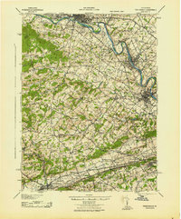
 1944 Reading1944 Print · USGSReading and its surrounding Berks County townships appear here during the height of the mid-century industrial era. Genealogists and historians can trace family locations through dozens of named schools like Shirk Sch and Cedar top Sch, or locate ancestral sites at Oley Furnace and Charles Evans Cem.
 - 1944 Map of Newark, 1971 Print
 1944 Newark1971 Print · USGSThe industrial corridor from Philadelphia to New York was in a period of massive transition during the mid-forties. Genealogists and researchers can trace the rail lines of the Lehigh Valley RR, locate military installations like Picatinny Arsenal, and explore the early sprawl near Levittown.5 unique versions available
 - 1946 Map of Reading
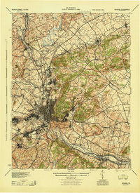
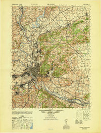 1946 Reading1946 Print · USGSBerks County's industrial and agricultural heartland is documented here just after the war, centered on the bustling hub of Reading. Genealogists and historians can trace family-named landmarks like Hecktown Sch, Friends Meeting House, and Van Reeds Mill.
 - 1947 Map of Birdsboro, 1967 Print
 1947 Birdsboro1967 Print · USGSBerks County’s industrial and colonial history converge along the Schuylkill River in the late 1940s. Genealogists and historians can trace family sites like the Daniel Boone Homestead and the Exeter Friends Meeting House.4 unique versions available
 - 1949 Map of Newark
 1949 Newark1949 Print · USGSThe industrial corridor between Philadelphia and New York comes alive in this post-war survey. Genealogists and historians can trace the massive rail networks of the Reading Railroad and locate major installations like Fort Dix or Picatinny Arsenal.2 unique versions available
End of results
Showing maps 1-8 of 8
Top cities near Union Township
- Reading historical maps
- Pottstown historical maps
- West Goshen Township historical maps
- Muhlenberg Park historical maps
- Limerick Township historical maps
- Phoenixville historical maps
See more
Top neighborhoods of Union Township
Frequently asked questions
- What are the different types of historical maps available for Union Township?
- What is the oldest map of Union Township?
- Where can I purchase historical maps of Union Township for my home or office?
- Where can I download high-res historical maps of Union Township?
- Are there historical topographic maps available for Union Township?
- Is there historical aerial imagery available for Union Township?
- Where are historical maps of Union Township sourced from?