1990s Maps of Wilmot Township, Pennsylvania
Explore 2 historic maps of Wilmot Township from the 1990s. These maps offer a rare glimpse into what life looked like during the 1990s — showing old roads, neighborhoods, homes, and landmarks that have changed or disappeared over time.
Whether you're researching your family's past, planning a metal detecting trip, or studying how Wilmot Township's landscape evolved across the 1990s, these high-resolution maps are a powerful tool for exploring the history of this region.
- Focus on a specific era: All maps on this page are from the 1990s, giving you a focused view of this time period.
- See what’s changed: Compare century-old streets, trails, and buildings to today's modern landscape using overlays and satellite layers.
- Research with precision: Use these maps for genealogy, historical research, land use analysis, or educational projects.
- View, download, or print: Maps are fully viewable online in high resolution, and can be downloaded or printed for your own records.
Start exploring Wilmot Township's history through authentic maps from the 1990s. This is your window into the past.
Wilmot Township, PA maps
(2)- 1998 Map of Laceyville, 1999 Print
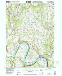 1998 Laceyville1999 Print · USGSIn the Susquehanna River valley during the late nineties, this area shows the persistent geography of river-bend settlements and mountain gaps. Genealogists can locate family sites at Spring Hill Cem or trace the rural landscape near Spring Hill Sch and Skinners Eddy.
 - 1999 Map of Wyalusing, 2001 Print
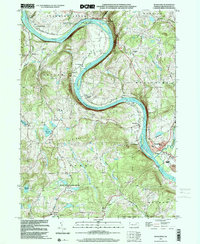 1999 Wyalusing2001 Print · USGSBradford County’s river valley is centered here during the late nineties, where the Susquehanna's dramatic bends shaped local settlement patterns. Genealogists can trace family footprints near French Asylum, Terrytown, and the historic Standing Stone Ch.
End of results
Showing maps 1-2 of 2
Top cities near Wilmot Township
- Towanda historical maps
- Harveys Lake historical maps
- Wysox Township historical maps
- Sheshequin Township historical maps
- Rush Township historical maps
- Ulster Township historical maps
See more
Top neighborhoods of Wilmot Township
- Hollenback historical maps
- Ellwell historical maps
- Sciotavale historical maps
- Cumiskey historical maps
- Sugar Run historical maps
Frequently asked questions
- What are the different types of historical maps available for Wilmot Township?
- What is the oldest map of Wilmot Township?
- Where can I purchase historical maps of Wilmot Township for my home or office?
- Where can I download high-res historical maps of Wilmot Township?
- Are there historical topographic maps available for Wilmot Township?
- Is there historical aerial imagery available for Wilmot Township?
- Where are historical maps of Wilmot Township sourced from?