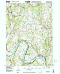
1998 Map of Laceyville
USGS Topo · Published 1999About this map
Laceyville and Skinners Eddy anchor the southern reaches of this landscape, situated along a dramatic horseshoe curve of the Susquehanna River known as Quicks Bend. The topography is defined by the steep rises of Browntown Mountain and Tuscarora Mountain, which hem in the river valley. Transportation patterns in the late 20th century still reflect the historical reliance on the river corridor, with the Lehigh Valley railroad tracks tracing the northern bank.
Find a feature on this map
54 named features on this map. Tap any name to fly to it.
Don’t see what you’re looking for? This feature index may not catch every label — zoom into the map to look around manually.
Map Details
Editions of this 1998 Laceyville Map
This is the sole edition of this map. No revisions or reprints were ever made.
Other maps of this area

1923 · Towanda
USGS Topo · 1:62,500

1926 · Towanda
USGS Topo · 1:62,500

1943 · Towanda
USGS Topo · 1:62,500

1943 · Monroeton
USGS Topo · 1:62,500

1943 · Le Raysville
USGS Topo · 1:62,500

1945 · Le Raysville
USGS Topo · 1:62,500

1945 · Meshoppen
USGS Topo · 1:62,500

1945 · Auburn Center
USGS Topo · 1:24,000

1945 · Jenningsville
USGS Topo · 1:24,000

1945 · Meshoppen
USGS Topo · 1:24,000
Featured Places
- Wilmot Township, PA
- Laceyville, PA
- Herrick Township, PA
- Silvara, Tuscarora Township
- Browntown, Wyalusing Township