
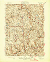
1945 Map of Le Raysville
USGS Topo · Published 1945About this map
Le Raysville serves as a central hub in this mid-century survey of the rural borderlands between Pennsylvania and New York. The landscape is defined by the high ridges and deep-cut creek valleys of the Endless Mountains region, where communities like Warren Center and Middletown Center are connected by a network of winding roads. This era shows a well-established rural social structure, with local education and faith centered on sites like Flynn Sch and St Patricks Ch. The map details numerous family-named landmarks and crossroads, such as Chaffee Cors and Stone House Corner, which indicate the enduring legacy of early settlement patterns. Along the northern edge, the Pennsylvania New York State Boundary Line bisects small watersheds, including those feeding Choconut Creek and Apalachin Creek. The presence of several localized burial grounds, including East Rush Cem and Darling Cem, provides significant points of interest for those tracing lineage in Susquehanna and Bradford counties.
Find a feature on this map
64 named features on this map. Tap any name to fly to it.
Don’t see what you’re looking for? This feature index may not catch every label — zoom into the map to look around manually.
Map Details
Editions of this 1945 Le Raysville Map
2 editions found
Other maps of this area

1901 · Apalachin
USGS Topo · 1:62,500

1903 · Owego
USGS Topo · 1:62,500

1904 · Binghamton
USGS Topo · 1:62,500

1904 · Apalachin
USGS Topo · 1:62,500

1906 · Catatonk
USGS Topo · 1:125,000

1923 · Towanda
USGS Topo · 1:62,500

1926 · Towanda
USGS Topo · 1:62,500

1935 · Binghamton West
USGS Topo · 1:24,000

1942 · Binghamton West
USGS Topo · 1:31,680

1943 · Towanda
USGS Topo · 1:62,500