
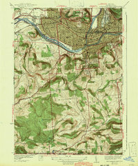
1942 Map of Binghamton West
USGS Topo · Published 1942About this map
The Susquehanna River and Chenango River converge near the heart of this urban and rural landscape, framing the industrial and residential core of the region during the early 1940s. The dense city grid, centered around the Court House and Post Office, gives way to the prominent ridges of South Mountain and Ingraham Hill to the south. Transportation is defined by the heavy rail presence of the Erie RR and the D L & W RR, which follow the river valleys and support the growing settlements of Westover and Stella. Moving away from the river, the terrain rises sharply toward Table Rock Ridge, where rural life is anchored by local institutions like the Ingraham Hill Sch and Grove Sch. Notable landmarks including the Childrens Home and Binghamton Hospital sit alongside extensive burial grounds such as Floral Park Cemetery, reflecting the established social fabric of the era.
Find a feature on this map
73 named features on this map. Tap any name to fly to it.
Don’t see what you’re looking for? This feature index may not catch every label — zoom into the map to look around manually.
Map Details
Editions of this 1942 Binghamton West Map
2 editions found
Other maps of this area

1901 · Apalachin
USGS Topo · 1:62,500

1904 · Binghamton
USGS Topo · 1:62,500

1904 · Apalachin
USGS Topo · 1:62,500

1906 · Catatonk
USGS Topo · 1:125,000

1934 · Castle Creek
USGS Topo · 1:24,000

1935 · Binghamton West
USGS Topo · 1:24,000

1935 · Chenango Forks
USGS Topo · 1:24,000

1937 · Binghamton East
USGS Topo · 1:24,000

1942 · Castle Creek
USGS Topo · 1:31,680

1942 · Chenango Forks
USGS Topo · 1:31,680